
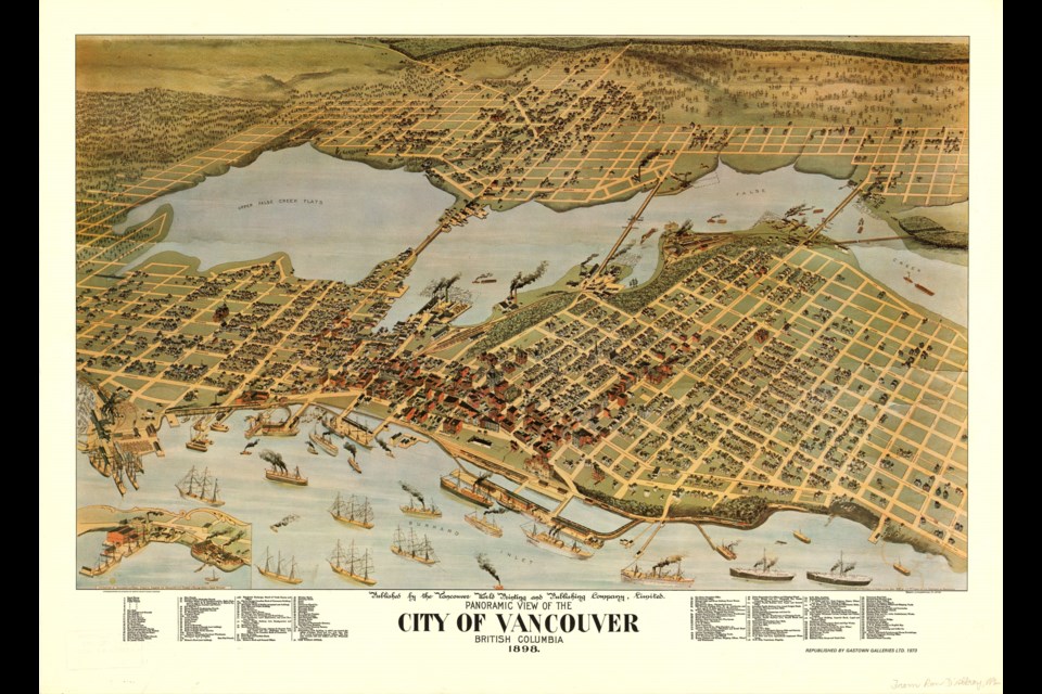
If you look at this map and think, 'This isn't the Vancouver I know!' there are a few reasons for that.
First, and simplest, is the orientation. The view is from the north, looking south over the Burrard Inlet, as if the map were drawn by a giant standing at at the Port of Vancouver in North Vancouver.
Second, it's from 1898. A lot has changed since then. And by a lot, we mean virtually everything. Cars were new and rare, with most people relying on horses, tall ships with huge masts were still a common sight as a working ship (not a novelty), and electricity was just being added to Vancouver. At this point sliced bread was still decades in the future.
In 1898 the centre of town was more Water and Carrall streets and while Granville Street is built up, areas further west are quite sparse. Coal Harbour isn't even worth putting on the map at the time. To the south, Kingsway is still just the road to New Westminster, with a forest running alongside a good chunk of it.
The furthest street to the south is 21st Avenue and roads heading directly south disappear into the forest; in one case Steveston is the destination.
Road names are a bit confusing, too. In some cases, the current names are still years off. You won't see Main Street, Kingsway and or Broadway on this map. Smaller streets are also different, like Princess Street running perpendicular to its current version (Carl Street is gone now, and East Pender took the roadway that was Princess).
Few buildings remain from this time. The most prominent on the map is the CP station, down at the waterfront which was replaced. While there is a Hotel Vancouver on the map, that's not the current one (we're on the third Hotel Vancouver). The Alhambra Hotel should be on there, though it's not particularly recognizable on Water Street. The Christ Church Cathedral is on there but it doesn't stand out too much.
The map was a supplement in a Vancouver newspaper called the Daily World. A legend at the bottom matches numbers on buildings with local places of importance, including yacht clubs, slaughterhouses and hotels.
Some may recognize the map from a book cover. Chuck Davis used it in his History of Metropolitan Vancouver.


