
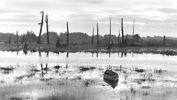
 A ghost forest of dead red cedars stands along the banks of the Copalis River in Washington state. The grove is one of the clues that led scientists to reassess their understanding of the potential size of earthquakes that can be generated in the Cascadia Subduction Zone off the Pacific Northwest Coast. Photo SUPPLIED, BRIAN ATWATER, 1997, UNITED STATES GEOLOGICAL SURVEY
"When the next very big earthquake hits, the northwest edge of the continent, from California to Canada and the continental shelf to the Cascades, will drop by as much as six feet and rebound thirty to a hundred feet to the west – losing, within minutes, all the elevation and compression it has gained over centuries. Some of that shift will take place beneath the ocean, displacing a colossal quantity of seawater. The water will surge upward into a huge hill, then promptly collapse. One side will rush west, toward Japan. The other side will rush east, in a seven-hundred-mile liquid wall that will reach the Northwest coast, on average, 15 minutes after the earthquake begins. By the time the shaking has ceased and the tsunami has receded, the region will be unrecognizable.”
– “The Really Big One” by Kathryn Schulz, The New Yorker, July 20, 2015
John Clague, Department of Earth Sciences, Simon Fraser University, speaks at the Parkgate branch of the North Vancouver District Library on Wednesday, Oct. 11 at 7 p.m. about Earthquake Hazards and Risks on Canada’s West Coast.
Thunderbird meets Killer Whale at the confluence of sea and sky. They do battle, over and over again as they have for millennia.
Squamish Nation member Latash–Maurice Nahanee relates the traditional stories of his people to the Squamish Valley landscape he is intimately familiar with. He associates stories about Thunderbird and Killer ?Whale with Black Tusk mountain, a subduction zone stratovolcano in the Garibaldi Volcanic Belt, the northernmost segment of the Cascadia Volcanic Belt, which includes Mount St. Helens.
In the Squamish language, Black Tusk is known as t’ak’t’ak mu’yin tl’a in7in’a’xe7en – “Landing Place of the Thunderbird.”
The Squamish tell of major disasters and great loss of life connected to earthquakes and landslides that have taken place in the Rubble Creek area.
“The Killer Whale was terrifying our people by coming up on the beach and eating all the Squamish people,” says Latash. “Thunderbird got mad at him and flew down and captured that whale and started shaking the whale, and all these bones came out of the whale. The people saw their relatives and started putting all these bones together, and they did some magic and all those bones became people again.”
In the oral traditions of Coast Salish cultures and other Pacific Northwest First Nations, Thunderbird and Killer Whale tales relate specifically and metaphorically to past catastrophic events even though they are presented in mythical scenarios. They speak of unspeakable things that once took place along the coastal corridor from northern California to southern B.C.
Forty times, to be exact, since the last glacial period, according to earth scientists. Nineteen of which were full rupture 9.0 megathrust earthquakes along the 1,000-kilometre Cascadia Subduction Zone (CSZ), the last of which took place on Jan. 26, 1700 at 9 p.m.
Up until recent decades, no one thought earthquakes of such magnitude could occur in the Pacific Northwest. But thanks to research by American, Japanese and Canadian scientists, geological knowledge of what the CSZ is capable of has changed considerably.
We know the date of the last megathrust earthquake in the CSZ because of an orphan tsunami that hit Japan in the winter of 1700. Local records documented widespread damage although at the time they did not know what had caused the massive ocean wave action.
In the 1990s Japanese scientists, including Kenji Satake of the Geological Survey of Japan, were tipped off to look back in the historical records after learning of the work of geologist Brian Atwater, endocrinologist David Yamaguchi and other researchers associated with the University of Washington. They determined through analysis of soil deposits in ancient marshes in estuaries on the Washington state coastline that a cataclysmic earthquake had occurred in the not too distant past.
Meticulous Japanese tsunami records not only concurred with that finding, they also narrowed it down to the day and hour that the ocean wave struck their coastline.
During the late ’80s and ’90s, SFU professor John Clague worked with a team on the Canadian side of the border to confirm the CSZ evidence found by his colleagues in the U.S. and Japan.
“Brian Atwater stimulated a lot of interest in this problem,” says Clague. “Prior to that there was really very little appreciation that we get these extraordinarily large earthquakes. A number of geologists took it upon themselves to provide additional evidence for this earthquake.”
Clague did most of his research on Vancouver Island, particularly along the west coast in Tofino, Ucluelet, as well as in Victoria and up island towards Gold River.
“The evidence that we found was that during these earthquakes, the level of the land shifts along our coast and the Washington and Oregon coast,” he says. “The land drops down suddenly during an earthquake and so a very good place to document that geologically is along the shoreline because you record that down-dropping of the surface of the earth in the layering in the coastal sediments that you see in these areas.
“That was really what Brian Atwater had found was this sudden evidence of down-dropping. In addition, the bigger quakes – and we’ve seen this in very similar big earthquakes over the past 20 years in the Indian Ocean and Japan and Chile – they produce tsunamis and the tsunamis also leave evidence in the geologic record in the form of layers of sand and gravel that are transported landward from the sea and left in these coastal environments.”
Clague will go into detail about his research work at the Parkgate branch of the North Vancouver District Library next Wednesday, Oct. 11 at 7 p.m. in a talk entitled “Earthquake Hazards and Risks on Canada’s West Coast.”
While the CSZ danger is real and will eventually happen, Clague says the risk of more frequent, magnitude 6 and 7 crustal earthquakes, is even greater than that of the much larger, but rarer magnitude 9 events.
“The public doesn’t fully appreciate the biggest ones are not the biggest problem in my mind,” says Clague. “They are very rare and only occur on average every 500 or 600 years. If one does occur it’s big trouble, but because they are so rare the risk is actually lower than the average person might expect it would be.”
Recent earthquakes, like those that hit Mexico City in the summer and Christchurch, New Zealand, in 2011, pose far greater risks to urban populations, according to Clague.
“These are much smaller earthquakes but they can have sources and epicentres very close to our cities. In the magnitude 9 earthquakes, the sources are offshore so the energy that’s released by that earthquake is huge but it tends to diminish as the earthquake waves move inland from the sea floor.”
Earthquakes occur along fault lines. Once you’ve identified the faults that potentially could slip during an earthquake, then you know where the source is.
“The waves that produce damage radiate out from the source,” says Clague. “When you think about Richmond, the North Shore of Vancouver, Burnaby, they are not going to be significantly different in terms of distance from the epicentre. What does differ is the intensity of shaking caused by our local geology and our local topography. There are places in Metro Vancouver that are going to experience higher levels of ground shaking than others.”
Determining the effects of an earthquake on different areas of the Lower Mainland would be greatly enhanced by a seismic microzonation study, says Clague. It’s something that has been done in Victoria and Seattle but not Vancouver.
“I think that’s almost criminal that it hasn’t been done,” says Clague. “When you look at the potential damage from an earthquake to a city of over two million people, we need to know how different the shaking is going to be in different parts of the city. It’s controlled by the subsurface soils, the sediments that underlie the ground surface.”
Low-lying areas of the Lower Mainland are highly susceptible to liquefaction. Loose water-saturated sediments completely lose their strength when they are shaken and will behave like a liquid.
“On the North Shore they are typically associated with the river deltas where the rivers come into the sea,” says Clague. “The Capilano river delta down near the Lions Gate Bridge, the mouth of the Seymour River, parts of the industrial area that lie along the shoreline are all on liquefiable soils.”
Newer buildings are generally designed to minimize the impact of liquefaction, but buried gas lines, fibre optic cables, sewer lines and water lines are an entirely different level of problem when considering the effects of ground shaking.
“You cannot prepare the soils to deal with that linear infrastructure over large areas,” says Clague. “That would be damaged by liquefaction during an earthquake. We really need to try to improve our critical infrastructure and I consider buried utilities critical infrastructure.
“Seismic microzonation is baseline documentation. It won’t tell you when an earthquake will occur or how big it will be, but it will show us the difference in the intensity of shaking within the Metro Vancouver area. And that’s maybe $100,000 to $300,000 investment. It sounds like a lot, but it isn’t really.”


