
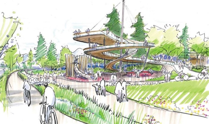
 The Lookout
The design concept for Arbutus Greenway envisions eight “character” zones along the route inspired by specific features of those areas.
Released on April 19, the concept will be displayed for feedback at open houses scheduled for April 21, 25 and 28.
The city document outlines the overall short, medium and long-term design plans for the pedestrian path, bike path and future streetcar route, as well as the vision for each of the zones, which range from 0.5 to two kilometres in length.
Zoning in
Zone one, for instance, is dubbed “Harvest Table.” It stretches from West Sixth Avenue at Fir Street to West Broadway. The idea is for the community to “come together over urban agriculture and food,” so it features edible landscaping, long community tables for dining outdoors and an area for pop-up activities. Meanwhile, zone eight — “The Lookout” — at the other end of the corridor would include a two-storey observation platform.
Lon LaClaire, the city’s director of transportation, said the goal of the design work was to look at the entire corridor as a “big opportunity to create a really special experience” while providing some kind of consistency along its entire length so users would feel comfortable walking and cycling it.
“It’s kind of like the seawall experience where there’s something about it that’s consistent. Then, through the process, we recognized that in doing that, as much as it’s similar along the corridor, there are really distinct zones and the character is really specific in each of those zones,” he said. "The design really recognizes that and builds off of what is unique about those very specific character zones. We’re pretty happy with where we’ve landed and, ultimately, the community had a big say in how that manifested itself in the actual designs.”
Last year, the city sought volunteers to help form the greenway vision. One hundred people of all ages, who the city called “design champions,” were selected from 22 Vancouver neighbourhoods to participate. They joined city staff and technical experts in a multi-day design workshop to dream up ideas. Input was also collected through public open houses and an online survey.
However, creating the design was a complicated process given constraints such as the greenway’s 15 to 20-metre width, its topography and the need to incorporate plans for a future streetcar.
Initially, LaClaire said the objective wasn’t to parcel the corridor up into sections.
“It’s more of an outcome than anything. It just happens to be that the corridor is similar for this amount of length and then it changes. And then it’s similar again for this amount of length and then it changes again,” he said.
Zone two, “Electric Alley,” sits between West Broadway and West 16th Avenue, an urban area that lends itself to more activity. The proposed design calls for it to be anchored by two plazas, one at West Broadway connecting with future rapid transit and another at West 16th. In between, overhead frames would define the section, which would also feature lights and public art.
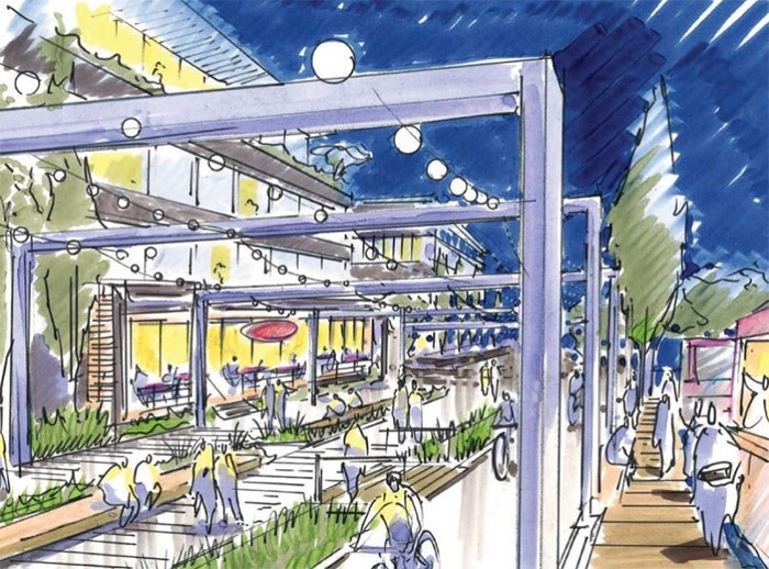 Electric Alley
That contrasts with the portion between 16th and King Edward — zone three, “The Ridge.” It’s parallel to a busy street on one side and a minor street on the other side. It has wide open vistas and then it turns the corner where it’s suddenly into the bushes.
Landscaping in this zone would create areas to sit and relax or socialize. There would also be areas for urban ecology such as pollinator gardens and habitat boxes for birds, bees and bats.
Other zones have been dubbed, for descriptive purposes, “Woodland Bend,” “Kerrydale Pass,” “Garden Path” and “Marpole Meander.” Lookout points, exercise equipment, gathering places, performance areas, urban agriculture, a bike skills course, ping pong tables and a giant chess board are among features envisioned at various spots in those sections.
Walking, biking, streetcar
The final pedestrian and cycling paths will look different than the existing temporary path.
“What’s out there today is the minimum dimension path in order to separate walking and cycling, largely with a paint line,” LaClaire said. “The actual plan and the concept is to do much better than that — to create a really generous walking experience, a real separation from the cycling [with] plantings [and] large scale landscaping based on feedback we had from users.”
Design boards at the upcoming houses will outline the specifics.
The public will also see renderings of each zone along the route depicted with and without a streetcar, so they understand what the future looks like when a streetcar is in place.
Although it will take years for construction to be completed over the entire route, LaClaire said that doesn’t mean improvements to the temporary path can’t be made where necessary.
“Where we’re seeing conflicts, we might go in and widen the asphalt or separate the paths, similar to what we just did in False Creek South just east of the Cambie Street Bridge… we had a temporary path in place there for many, many, years. It was too narrow. We went in and widened the path. People were appreciative of that,” he said. “It’s still a temporary path, but it’s a far better temporary path."
The Arbutus Greenway's temporary path continues to be popular. Over the winter, about 1,000 cyclists and more than 2,000 pedestrians used it each day.
Controversy did erupt when the temporary path was first laid down, but LaClaire said users have not come out much to speak against it recently.
“Initially, there was a bit of reaction that the corridor wasn’t just going to be turned into a forest. There were some people that were concerned that now we’re going to be inviting the entire city to this corridor, which, in fact, we are. And that was something that was causing some initial discomfort,” he said. “We worked closely with the community to respond to their concerns but, with the temporary path open, they’re experiencing what it’s like having people pass through the neighbourhood in that fashion. Sometimes, I think, people’s fear of the unknown [is] bigger than [the reality]. Now that it’s operating, I think they actually appreciate it’s a pleasant thing to have people walking, strolling, biking by their neighbourhood.”
Building the greenway
One of the advantages of creating zones, is that each is a manageable development length.
“For us to mobilize and build just one block of any greenway is almost not worth it. There’s a certain amount of critical mass that you want to have before you pull out the equipment…” LaClaire explained. “Ultimately, in the next capital plan, we’ll look at a zone or two, or perhaps three, depending on how things go, [where it looks] like now is a good time to develop.”
However,the idea isn’t to start construction at one end and slowly move towards the other. The plan is to be efficient with city resources and hold off on sections where the city is actively planning.
“Around Broadway, we have the Broadway corridor work coming. The land use planning exercise that we do there is probably going to mean that some of those [adjacent areas] are going to develop. So it would probably be best that we held off on that stretch for a bit,” LaClaire said. “The construction of the [rapid transit] station is going to be really disruptive on Broadway. That whole portion of the greenway won’t be ready for its final build for a while yet.”
Other sections such as “The Ridge” zone that runs along Arbutus Street will require less work, involving mainly walking and cycling paths, with a bit of greenspace.
“If you’re in a bus or a car on Arbutus, you can kind of look up on the hill and see the people walking and cycling, which is kind of cool. It’s also an area which is kind of isolated. There’s no adjacent developments,” LaClaire said. “There are streets on both sides. It’s relatively cheap to build because most of the construction is earth moving and planting. That’s one that we would probably prioritize as an early deliverable — [it’s] really highly visible, a bit of a showcase for the corridor.”
What’s in a name?
While the zones have been given descriptive names for place-making purposes, they’re not meant to stick.
The city is working with three First Nations — Musqueam, Squamish and Tsleil-Waututh — on matters such as naming and visibility, wayfinding, ethnobotany and public art.
With respect to naming, the idea is to use the greenway as a pilot project for Indigenous naming and increasing the visibility of the First Nations, including exploring opportunities to rename the overall greenway and specific sections with traditional place names. Signs would be in English, h?n?q??min??m and S?wx?wú7mesh.
Covering costs
Funding to develop the corridor is expected to come from the sale of excess lands not needed for the greenway, partnerships with senior levels of government, community amenity contributions and City of Vancouver capital plans.
The city doesn’t have a cost estimate for the whole project, which will be developed over years. LaClaire said staff have some early estimates for each section although he didn’t release those figures.
“We think that some sections might stay in a temporary state for a very long time. At the same time, the advantage of having us develop a master plan or a vision for the corridor [is that] if any opportunities jump up at us, whether they are federal or provincial contributions, outside sources, partnerships or any adjacent development, this allows us to jump on the implementation of that section,” he said.
The city, meanwhile, has already determined that the area between West First and West Fifth avenues — parcels of land measuring about 6,460 square metres — won’t be needed for the greenway. Known as the “Option Lands,” they will be removed from the Arbutus Corridor Official Development Plan and retain existing zoning. Any potential rezoning will be considered in a future public process.
If the lands are rezoned, CPR has the option to repurchase these lands from the city. If CPR doesn’t exercise that option, it will share in the proceeds of any sale of excess lands.
The only other section, based on a preliminary review, where there may be excess land is in Kerrisdale (zone five), although during the detailed design process for the greenway, other areas may be identified. A separate planning process will determine future uses of any excess land.
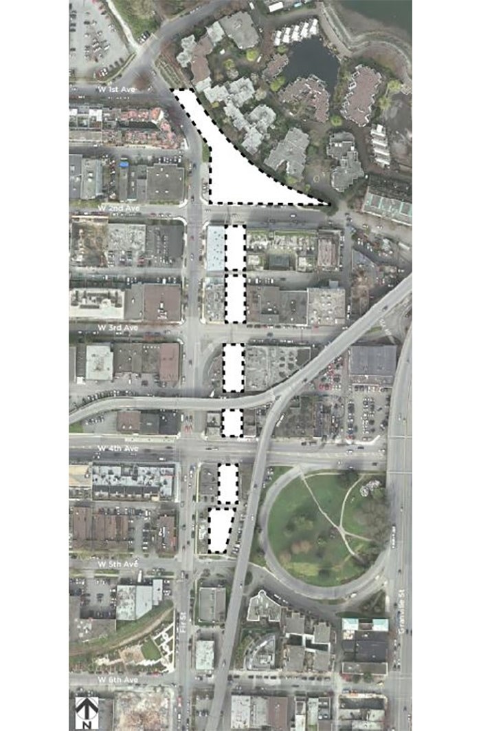 “Option Lands” that won’t be needed for the greenway.
Collecting feedback
City staff gave some community associations a sneak peek at the design concept for the greenway earlier this week.
“Their comments were really positive [with some] saying it exceeded expectations in terms of what the potential of the design is overall,” Susan Haid, the city’s assistant director of planning, told the Courier.
“A vision is really critical in terms of driving change. It’s a really big vision and I love the way that it’s broken down into areas — that each has an identity and you think about passing through a series of experiences on the greenway… the community leaders are extremely jazzed about the ideas. It’s super exciting.”
Haid said the city welcomes feedback through the open houses and through an online survey on the city’s website. The plan will be tweaked based on input and the goal is to bring the design concept to city council for its consideration in July.
“If there’s something that’s missed or doesn’t fit, our ears are all open at this point,” she said.
More information about the design concept, open houses and online survey can be found here
noconnor@vancourier.com
@naoibh


