Climate change is a double challenge for communities in southwestern B.C. that cluster at the mouth of the Fraser River and across the broad delta of rich soils its waters have deposited over millennia.
On one hand, the river carries billions of litres of water south from the mountain ranges of the interior to the coast, aiding everyone from farmers to fishers. However, the benchmark floods of 1948 and 1894 remain influential in the imagination of those charged with protecting the region from devastating water damage.
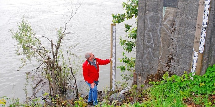 Steve Litke of the Fraser Basin Council measures Fraser River water levels at the Mission gauge. The dark plaque on the concrete marks the peak water height set in 1894. (Denise Palmer)
Sea levels have steadily increased since readings were first taken in the 1870s. Provincial estimates indicate that B.C.’s south coast could see water levels rise a further 1.2 metres (more than seven feet) by 2100, potentially creating dramatic storm surges in coastal areas.
Provincial guidelines have many municipalities considering a construction level of at least 4.5 metres to protect buildings against flooding.
Coastal farms, meanwhile, face a rising water table and the risk of more saline soils as sea levels rise and sediment continues to accumulate at the mouth of the Fraser River. Rising sea levels combined with sedimentation and lower flows through the Fraser River mean salt water extends farther up the Fraser River than ever before.
The situation is forcing coastal municipalities like Delta and Surrey to rise to the occasion, drafting plans to protect homes and businesses from the waters.
“The reason you’re seeing us and others advance their coastal studies is that’s probably where we’re most vulnerable the soonest,” said Carrie Baron, drainage manager with Surrey’s engineering department, which is developing a coastal flood adaptation strategy that will be presented to city council in early 2019. “It’s not necessarily tomorrow, but that’s where we’ve figured out we’re the most vulnerable from sea level rise.”
While a great deal of infrastructure is already in place, including an extensive network of coastal dikes to keep water out and drainage canals to channel water on protected lands, improvements are needed to deal with what lies ahead.
“It used to just drain through the sand,” Baron said of stormwater in protected areas like Crescent Beach. “The tides have gradually gotten higher, and now it doesn’t drain.”
The answer in Crescent Beach was storm sewers to improve drainage, while in Delta the local farmers’ institute worked with the B.C. Ministry of Transportation and Infrastructure to secure a new $22 million pumping system to improve irrigation and drainage on 15,500 acres of farmland.
Both municipalities are also reinforcing dikes to protect existing developments as well as new developments such as the Southlands in Tsawwassen and Marina Gardens in Ladner.
While hopes are high, the waters may well be higher.
“It will protect us for a while; it won’t protect us until 2100,” Baron said of upgrades to seven kilometres of dikes along the north side of the Serpentine River.
A growing number of examples show the devastation possible.
Grand Forks experienced a 200-year-flood event this spring that saw the Kettle River rip through dikes, destroying homes and businesses. Bylaws established a decade ago to protect new developments were rendered moot by the force of the water.
A 2016 study for the Fraser Basin Council suggests that a similar, 100-year flood event in the Lower Mainland – one on the scale of 1894 – could cost upwards of $32 billion.
To address the risk, the recent report on the province’s response to flooding in 2017 recommended that “B.C. expeditiously determine the condition, vulnerability and effectiveness” of the province’s dikes.
Upgrading the province’s 1,100 kilometres of dikes won’t come cheap. Some estimates peg the cost at $2 million per kilometre, an amount that far outstrips what municipalities could raise through property taxes.
A less costly option is a managed retreat from vulnerable areas, something Surrey is considering for up to 400 properties in Crescent Beach. It was also proposed for portions of Delta; under one model, up to 80 per cent of local farmland could be sacrificed to the sea.
Whether municipalities can afford to take such drastic measures is another question. Surrey continues to consider its options, and the report on the 2017 flood events emphasized the need to balance community viability with climate change strategies.
The report also argued for partnerships among all levels of government to address the challenges.
“It’s clear from everyone that it would probably require federal and provincial assistance,” said Mike Brotherston, who oversees climate action strategies for Delta.
This is where ongoing work by the Fraser Basin Council to develop a funding model is important.
“We’re really building up a case that it’s a good return on investment to reduce flood risk before an event rather than clean up the mess and rebuild after,” said Steve Litke, the council’s senior program manager.