
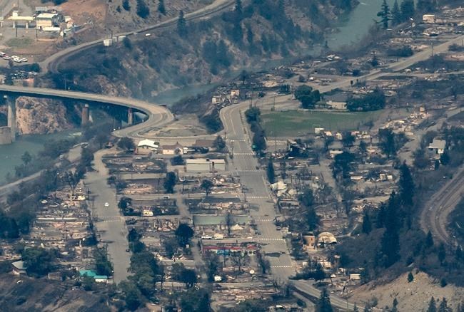
The province’s chief coroner says at least two people died in the forest fire Thursday which destroyed the village of Lytton.
Those deaths won’t be officially confirmed until it is safe for officials to go into the village. Several people are still unaccounted for and the death toll could rise from the fire Thursday evening which was fanned by strong wind gusts and grew rapidly in intensity, taking the residents of Lytton by surprise.
“We have received preliminary reports of two fire-related fatalities near Lytton,” said chief coroner Lisa LaPointe, at a Friday afternoon news conference in Victoria.
“We have sent a coroner’s team. They are standing by. It’s not safe to enter the area, and once they receive the approval to go to the site they will conduct their investigation and at that point we will be able to confirm officially whether or not there are fatalities, although we believe we have two.
“Hopefully we will not receive any other supports but we will be sure to advise folks as soon as we have any information. I know there’s a great deal of concern and we certainly empathize with the people of Lytton and their friends and family across the province and across the country.”
Emergency Management B.C. is preventing people from entering the village due to concerns about toxic smoke from the buildings and vehicles destroyed in the fire.
In B.C. there are 136 active fires, 14 of which started in the past two days. Most of the new fires are centred in the southeast of the province and southern Interior. Nine are considered fires of note, serious enough to prompt evacuation alerts or orders. There are 40 active fires in the Cariboo and 33 in the Kamloops Fire Centre.
In its Friday afternoon update, the province announced it has 1,362 homes under evacuation orders and 950 homes have been issued evacuation alerts.
After a week of record or near-record temperatures and very little rain, the fire danger rating is rated as high for the Prince George Fire District - one notch below extreme.
Open burning is prohibited in the Prince George Fire Centre and a campfire ban has been in effect since June 25.
A heat warning remains in effect for the city of Prince George and people are being warned to take extreme care when venturing into forests to prevent fires. Friday’s high wass expected to reach 26 C, 10 degrees or more cooler than it was for the last few days of June. No rain is expected until Monday and the predicted highs will be 26 C on Saturday and Sunday under mostly sunny skies.
Of the 33 wildfires burning in the Prince George Fire Centre, three are considered fires of note, none of which are currently threatening any populated areas. All are in rural areas northwest of Fort St. John.
The largest of the three is a 6,000 hectare blaze south of Buckinghorse River to Sekanni Chief River, which was discovered on Monday. An alert issued by the Peace River Regional District has been rescinded.
The Beatton River fire first reported on Monday remains burning out of control over a 2,400 ha area. A third fire, reported on Tuesday, is estimated at 2,856 ha in size. Both are close of the Alaska Highway between Pink Mountain and Prophet River and travelers are being warned to expect delays.
Thursday’s lightning storm touched off several smaller fires closer to Prince George north of Bear Lake, including a half-hectare blaze near Carp Lake and a similar-sized fire near Hambone Lake. There’s also a 15 ha fire burning in the McGregor Mountain range between Parsnip River and the north side of Crawford Mountain.
Drive BC issued an alert Friday afternoon to warn road travelers of a forest fire near 100 Mile House on Watch Lake Road between Highways 97 and 24. The road is open to local traffic only.
Smoke from thefires northeast of Prince George is apparently drifting our way. According to the website FireSmoke.ca. we could be affected by wildfire smoke by as early as 3 a.m. Saturday.
The Prince George Fire Centre is the largest of six regions in the province, a 31.8-hectare area that is 10 times the size of Vancouver Island. The rugged, largely uninhabited area extends north to the Yukon and Northwest Territories borders and east to Alberta. The region includes the northern part of the Interior Plateau and Omenica Mountains to the north, sections of the Rocky Mountain Trench and Peace Liard country to the east and a section of the Cariboo Mountain range south of Quesnel.


