
Google Maps can break down directions for getting around town on foot, by car, or on public transit, but they don't factor in other popular modes of transportation. What about renting a bike, or using a car share, for a leg of your trip?
A new app that's beta-testing in Metro Vancouver offers "multimodal" ways to make single trips with a goal of helping the car-free population make the most of their time and money, while leaving the smallest eco-footprint possible.
 Photo: Shutterstock
The app is called Cowlines, and it was launched by Vancouver start-up Greenlines Technology Inc. So far, Cowlines has data from TransLink, BC Transit, Modo Car Coop, Mobi bikes, and taxis informing potential routes. Ultimately, says Greenlines, if car-sharing services like Uber and Lyft launch in Vancouver, they'll be added to the app, too.
Users have a choice of three options for route selection: fastest, best, and cheapest. Cowlines also tells the user the total trip cost, travel time, and the trip's CO2 emissions versus those of an equivalent trip in a private vehicle.
Launched March 5, Cowlines is running in invite-online beta testing mode through the end of the month, but will be made public in April. The app and its use is free, though it is only currently available for the iPhone (more platforms will be added later).
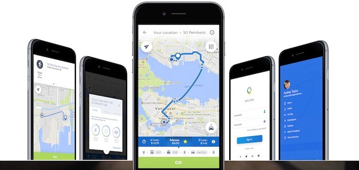 Screenshot/Cowlines
Oh, and the name: Yes, it does have something to do with cows. City planners use the terms "cowpaths" or "desire paths" to plot out where paths with go in public spaces, which is inspired by the way cows move across open fields.


