
The trail to Rice Lake isn't a mountainous hike but it's the first place to take friends and family who visit Vancouver and want to experience the North Shore mountains.
Round-trip, the Rice Lake trail is six kilometres long and not excessively strenuous, but it takes you to an awe-inspiring suspension bridge, magnificent views of Lynn Creek Canyon, lush rainforest and a serene lake with numerous viewpoints... plus a look back in time.
A great hike, rain or shine as long as you wear the right clothing and footwear, the trail to Rice Lake is inspiring even on a dreary, rainy November day when mist hovers over the canyon. The path can be crowded on sunny days and weekends. My advice is to start your day early.
To reach Lynn Canyon Park by car, take Highway 1 and cross the Second Narrows Bridge to Mountain Highway. Turn right and head up the hill, then turn right at Lynn Valley Road followed by another right at Peters Road. Follow the signs to the parking lot or drive just past the Ecology Centre and Café to parking spots under the trees.
On public transit, the TransLink 229 bus from Phibbs Exchange drops you off at the park; translink.ca has a trip planner to get you there.
Once on the trail, most people get stabilized on the Lynn Canyon Suspension Bridge and quickly pull out their cameras. The bridge-which initially cost a dime to cross when it was built in 1912 and is now free-spans the canyon 50 metres above Lynn Creek where it narrows.

Once you cross the bridge, head left down a staircase leading to the canyon floor. A side trail to the left takes you to the banks of the boulder-filled creek where many people bring a picnic lunch in summer.
Have a quick drink of water ahead of the most strenuous section of the hike: a wooden staircase that leads to a connector trail to Rice Lake, located 15 minutes to the north. From this point, it's mostly flat or downhill until the very last section.
The trail eventually opens upon a picnic area at the end of Lillooet Road, but I recommend staying left, grabbing a map at the information board and following the signs back into the forest towards the twokilometre Rice Lake Loop. Be aware there are no dogs allowed on this trail.
Shortly after the first gate accessing the loop, look left and you'll see artifacts from the late 1800s and early 1900s, including a section of an old logging flume used to carry chopped cedar shingle bolts 10 kilometres from Lynn Creek headwaters to Rice Lake. This was once a processing area for logging companies and a sign of Vancouver's nascent resource-based economy.
Next along the loop are two large boulders marking the memorial to a plane crash 65 years ago on a remote ridge of snow-capped Mount Elsay, which on a clear day can be seen through the trees. The TransCanada Air Lines flight from Lethbridge went missing in April 1947 and the plane wasn't found until 1994.
The names of the deceased are etched in the boulders.
In winter, the lake is often covered with a thin layer of ice and snow.
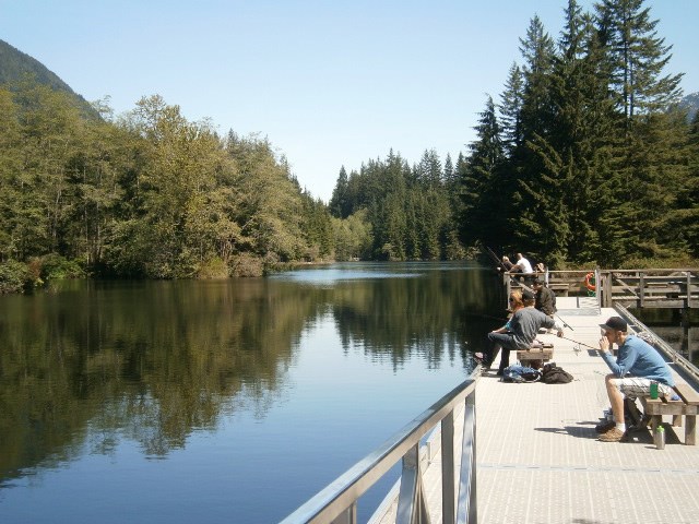
Near the end of the loop, you'll pass a small fishing pier where many people cast a line. The lake is stocked with rainbow trout.
There are numerous viewpoints and benches just off the trail. There is also a bridge to a tiny island. The spot is a perfect place to have lunch.
Eventually follow the signs back to the connector trail to the Lynn Canyon Suspension Bridge, then keep going down the Baden-Powell Trail towards the Twin Falls Bridge, which is near the bottom of the canyon and offers more views of the two small but powerful waterfalls beneath the bridge.
After crossing, you immediately climb a flight of stairs up the canyon wall then turn right onto a dirt service road, which takes you back to the parking lot.
Mike Hanafinis an experienced backcountry hiker who can see the forest and the trees. Reach him at [email protected].


