
A satellite image taken only hours before a wildfire sparked a "tactical evacuation" in West Kelowna shows how small fire was primed to grow, according to one expert.
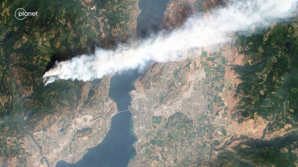
A photo provided to Glacier Media by the satellite imaging company Planet Labs shows the McDougall Creek wildfire on Thursday, Aug. 17, hours before powerful winds and soaring temperatures supercharged the fire.
Mike Flannigan, a professor at Thompson Rivers University in Kamloops researching fire weather and climate change, reviewed the image, noting the direction of the wind showed the fire was ready to take off.
"That's an active fire. It was going to burn," Flannigan said. "The fact that it was active at 11 a.m. shows the day was going to be an active day."
Flannigan tracked the fire as it grew eastward toward West Kelowna. The infrared satellite imagery he had access to didn't provide the kind of detail the Planet Labs image does, but it still showed the fire's growth.
By just after 6 p.m. Thursday, the wildfire had grown to 1,100 hectares and was displaying Rank 5 fire behaviour, a stage where fire has jumped into the crowns of trees and where firefighting is “extremely dangerous,” the BC Wildfire Service said
Within hours, the arrival of a dry cold front drove powerful, hot winds and pushed the fire east into the Okanagan Valley. A spokesperson for Planet Labs said their ability to photograph the wildfire as it grew was hampered by orbital delays and the vast amounts of smoke coming off the fire.
"It was a textbook, classic situation for explosive fire, made worse by the drought," Flannigan said.
Emergency personnel led a tactical evacuation across parts of West Kelowna overnight Thursday. Thousands of people were displaced as the fire burned a “significant” number of homes and jumped Okanagan Lake. As of Monday, 27,000 people have been placed on evacuation alert across the province.
"Little burning bits of trees or cones or whatever get carried by the wind and land on the other side of the lake," Flannigan said, explaining how the fire likely spread north of Kelowna.
On Friday, the University of British Columbia's Okanagan campus was evacuated, and Kelowna's landfill caught fire as people across the city scrambled to put out embers and save homes.
That evening, the extreme fire weather — and threats to people and property in the Kelowna and Shuswap Lake area, among others — prompted the province to declare an official state of emergency. Officials have urged outsiders not to visit the region, and over the weekend, banned visitors from using temporary accommodations in the South Okanagan, including everything from hotels to campgrounds.
Satellite images show wildfire's destruction
As of Monday, Aug. 21, the McDougall Creek wildfire had burned 11,000 hectares. Cooler temperatures and smokey skies have dropped the intensity of the fire, though an army of firefighters from across the province continues to work to extinguish structure fires and a sprawling fire line that continues to threaten the urban area.
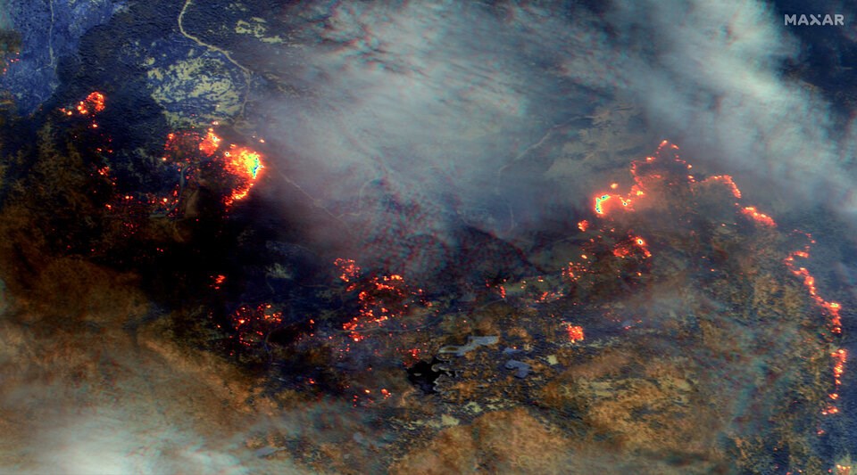
As the smoke cleared, images provided by Maxar Technologies showed some of the extent of the burning. Images taken Aug. 21 show vast swathes of brown where the McDougall Creek wildfire burned through forests and threatened nearby communities.
Fewer than 190 structures had been damaged or destroyed in the fire, according to the latest tally.
While the cause of the fire is still under investigation, Flannigan said all the ingredients for extreme fire weather had coalesced by Thursday afternoon.
"We're in uncharted territory," Flannigan said. "Things were extremely dry... which leads to very high intensifiers that are difficult to impossible to extinguish."
The latest round of extreme fire in B.C. adds to an already devastating wildfire season in the province and Canada. Over 14 million hectares of land have burned across the country, more than double the area that burned in 1989, the next most destructive year on record.
B.C. has also dwarfed its record for area burned in one season, with more than 1.7 million hectares burned.
While fire activity has calmed compared to the end of the last week, 3,500 firefighters and hundreds of aircraft are still engaged in fighting fires across the province. Another 300 firefighters from Mexico and South Africa are expected to arrive later this week.
Flannigan said that after a few days of respite, he's worried the conditions for fire weather could pick up again, bringing more hot, dry and windy days next week.
"I'm worried how long this fire season will go on," he said. "I worry about the mental and physical health of our firefighters.
"It's not over."


