
A B.C. company that helps make sense of satellite data says it has found a correlation between the 2021 wildfires and several bridges and sections of highway washed away during last fall’s catastrophic floods.
Launched 11 years ago in Prince George, B.C., SparkGeo has helped Silicon Valley tech companies like Nextdoor expand internationally, and environmental groups like the World Wildlife Foundation build a digital platform to help capture marine data in remote locations across the planet’s oceans.
But in some of its latest work, the team of geospatial analysts has turned its expertise to problems closer to home.
“There was fire here. There was flood here,” said Sparkgeo’s James Banting, referring to highway damage some say could add up to $7.5 billion.
“We're saying that something is there.”
That something emerged after the team of data scientists mapped out last year’s wildfires, record November rainfall and 36 sections of highway damaged by the ensuing flooding and landslides.
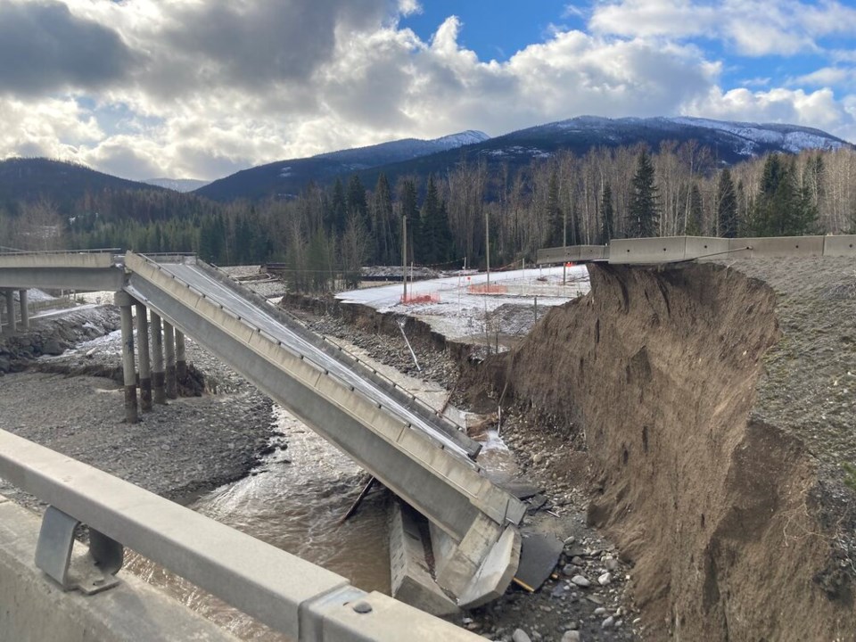
Most of the hill slopes and river crossings failed along the Coquihalla Highway — the busiest route linking Vancouver with the rest of Canada — between Hope and Merritt.
The three-dimensional digital terrain map flies you through burn-scarred valleys, where bridges see-sawed into the Coldwater River and sections of road crumbled under the weight of landslides.
Hillsides painted red reveal how hot the 2021 wildfires burned, a metric known as burn severity.
Along one stretch of the Coquihalla, seven damaged locations were mapped out, with most “in close proximity to the burn scar from the July Mountain Fire, which burned on both sides of the highway,” noted the researchers.
Swooping over a flooded Merritt, the viewer is taken up the Nicola River, where whole sections of Highway 1 cleaved into the rushing waters. And while those waters likely contributed to many of the failures, the 2021 July Creek fire burned adjacent to much of the damage, and at least one on-the-ground account points to a link between burn scars and powerful landslides near Tank Hill.
Describing the work as a “first pass,” Banting said much more needs to be done to draw a definitive picture of how wildfire impacted the costliest flood damage in the province’s history.
Independent fire ecologist Robert Gray, who reviewed the mapping, described the presentation of the factors at play as “impressive.”
“They are correct that there is likely a correlation between the 2021 fires and the November flood damage,” he said, “and also that much more analysis is needed.”
At first glance, the location of some washed out bridges and roads “hints at the role of fire,” said François-Nicolas Robinne, a wildfire risk scientist with the Canadian Forest Service. He agreed with Gray, however, that without tracing the origin in each watershed, “we won’t be sure.”
A forest turns to wax paper
How wildfire sets the stage for mudslides has been well-documented across the world.
When rain falls on an intact tree canopy, it gets caught in the leaves and needles, slowly dripping to the ground where it's soaked up by decomposing leaf litter and dead logs.
Like a giant sponge, the forest slows the path of rain and meltwater downhill, flattening peak flooding during extreme rainfall events in the same way social distancing can flatten the curve of COVID-19 cases.
But when a wildfire burns through a forest, the sponge effect is annihilated, explains Lori Daniels, a professor in UBC's forestry department.
To make matters worse, when a wildfire burns, a tree’s leaves and needles release aromatic oils that drip into the soil. Once cool, they create an oily coating below the ash and soil, like wax paper, said Daniels.
With nowhere to go, rainwater pools. Rivulets turn into puddles, which eventually tip downhill where they accumulate into flash floods and torrents. All that water inevitably flows to the lowest points in the landscape, often occupied by highways infrastructure or human settlements.
“Rain falling on the water repellent fire-scarred soils would have had a higher tendency to run off into the Coldwater River rather than being absorbed,” wrote the Sparkgeo team in their analysis.
“The increased volume of water flowing through the river would have increased its destructive power.”
How clearcut logging makes flooding worse
Others who examined Sparkgeo’s work warned that the widespread damage of B.C.’s highway system — let alone communities surrounded by mountains like Merritt and Princeton — is not a simple story of climate, flood and fire.
Younes Alila, a professor at the University of British Columbia’s department of forest resources management, pointed to a lack of on-the-ground work to directly link the bridge and highway failures to wildfire.
“Correlation is not causation,” said Alila. “A map like that would not stand in a courtroom.”
When diagnosing the cause of a mudslide, every site is different — geology and a mosaic of human disturbances upstream of a wildfire can matter as much as the fire itself, experts say.
Alila has spent years studying the interplay of wildfire and logging on flood risk. He says there is a vast body of work that shows destructive forestry practices, such as clearcut logging, are creating an unstable landscape across large swathes of B.C.
“We have known for a long time that clearcut logging and wildfire can cause floods. Intuitively, that goes without saying,” he said. “But the amount and rate of clearcut logging in tributaries and headwaters of the Fraser River and throughout the province have increased dramatically, especially over the last 20 years.”
Superimposed on those historic disturbances is a changing climate, which is making atmospheric rivers more severe and more frequent, Alila added.
Attribution science often involves dozens of scientists working together to quickly figure out how much climate change made an extreme weather event worse. The idea is to get the science to the world before the public and policymakers have moved on, or worse, rebuilt or relocated infrastructure into the wrong place.
The rapidly growing field has tended to focus on the impacts of climate change on extreme weather events.
Such studies have found that emissions from human civilization likely supercharged Hurricane Harvey’s devastating rains by a factor of 3.5. In B.C. last year, attribution studies found the record June heat dome was made 150 times more likely due to climate change. The November atmospheric river event, meanwhile, was made up to four times more likely due to the effects of human-released greenhouse gases.
Applying attribution science to the landscape, the canvas where climate change causes much of its damage, has received less attention. It’s a frontier Alila has been pushing for over a decade.
In one of his earlier studies on the subject, Alila found clearcut logging snow-covered forests could make the number of large floods in streams and rivers passing through them up to four times more likely.
More recently, he has been working in B.C.’s Interior in an undisclosed watershed where 18,000 kilometres of roads — and the drainage ditches and culverts that come with them — have increased stream density by 30 to 50 per cent.
That effect means water can more efficiently flow downhill, filling rivers and making flooding more frequent and more intense.
The watershed is typical to anywhere in B.C., says Alila, for the simple reason that companies cannot log without building roads.
As a result, climate scientists, policymakers, insurance companies and lawyers are now asking how much they should blame a flooding event on climate change, and how much worse it got because of previous wildfires or logging.
Government not moving fast enough to phase out clear cut logging
Outside of his lab and the Pacific Climate Impacts Consortium, which worked on the November flooding, Alila said attribution science is “under the radar” in B.C., particularly when it comes to the provincial government.
“The government of B.C. has not been managing the land at all on the basis of the most up-to-date science,” he said. “Only when there is a house on fire.”
When Glacier Media raised Alila’s claims the province is failing to transition away from clear cut logging, a spokesperson for the Ministry of Forests pointed to the role of the mountain pine beetle in decimating over 16 million hectares of forest and setting the stage for wildfire.
“A record 2.7 million hectares have burned in wildfires over the last 5 years,” wrote the spokesperson in an email. “In comparison, 888,000 hectares were harvested between 2016 and 2020.”
The spokesperson added that over the past 20 years, clear cut logging “with reserves” has been the most commonly applied forestry practice in B.C. — a practice, claimed the ministry spokesperson, that retains some forest for wildlife, water quality and terrain stability.
He also pointed to widespread and prompt tree planting efforts (“over 1 billion trees” planted since 2018) and changes to the Forest and Range Practices Act as steps the government has taken to diminish the impact of increased flood risk due to logging and climate change.
It’s a threat fire ecologist Gray hopes to have an answer to soon — he’s currently working with two other wildfire scientists to develop a methodology that would allow communities to model and assess potential mudslides before an extreme flooding event.
The idea, he said, is to “assess these situations before the disaster happens so we can target the necessary interventions.”
For Alila, the science is already clear: The most natural protection against landslides and floods is the vegetation cover.
“The problem is the minute [the B.C. government] starts to look at the real science and the recent science, it will be faced with the dilemma of having to change the way we manage the land in this province.
“It doesn't seem like there is a political will to do that.”


