
Stanley Park has been a staple in Vancouver's identity since it was founded in 1888, two years after the city.
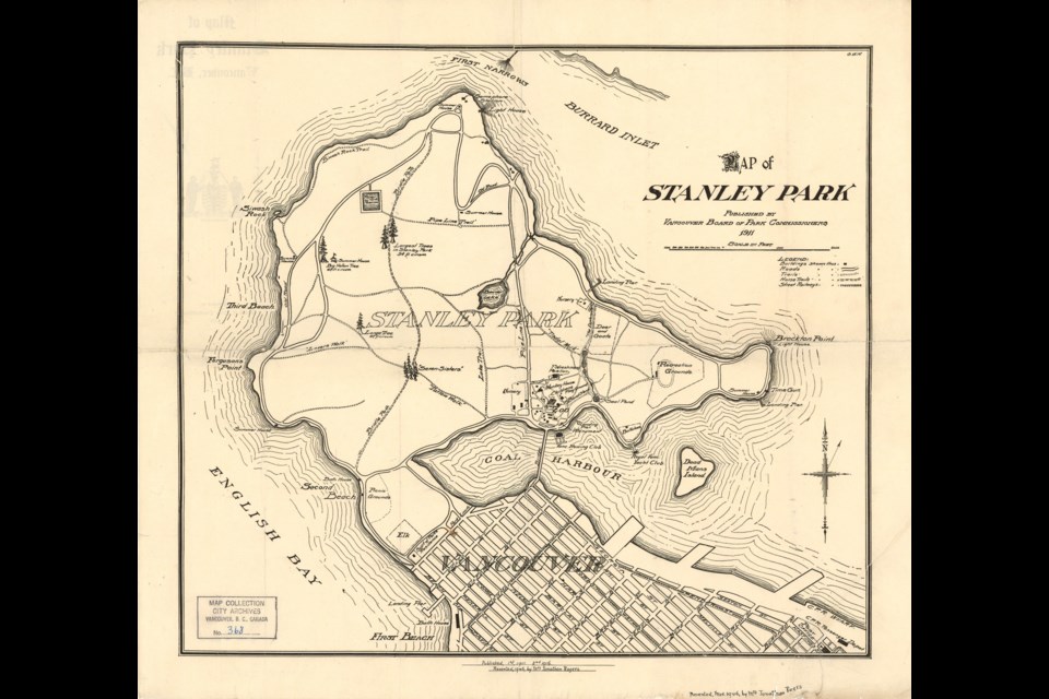
Obviously, the park hasn't always looked the way it does now, and it's evolved with the city's needs and wants. Back in 1911, the Vancouver Board of Park Commissioners commissioned a map of the park to help people find their way around the 1,000 acres of relative wilderness.
Highlights include a semaphore station at the northern tip of Prospect Point for communicating with ships at the entrance to Burrard Inlet. And while the 9 o'clock gun is shown it has a different, much better name: TimeGun.
Can we bring that back?
The biggest change, which is particularly conspicuous on a map, is Coal Harbour, which is much bigger than it is now. That's because shortly after this map was published the Lost Lagoon was created when a road and causeway was built heading into the park from West Georgia Street. This map shows the original, natural shape of the harbour. It also shows Deadman's Island as an island as well, before another causeway was built out to the little piece of land.
Lots of other recent additions aren't there, like the Vancouver Aquarium, and that's no surprise. Some pieces that seem to have been around forever are also missing, though, like Lions Gate Bridge (and the road leading to it) which wasn't built until 1937, and had no precursor. There are paths around the shore, but no seawall, either.
A few things on the map are still around today. The Brockton Oval was established in the 1890s and while it's not named on this map, it's drawn in. There's a lighthouse at Brockton Point, though the current structure was built in 1914. The Vancouver Rowing Club is noted on the map; it was founded in 1911.
Some of the famous trees are already noted as well, including the Hollow Tree and the original Seven Sisters.
Down in the area where the rose garden and aquarium sit now, there was already some build-up but there were some different features in 1911. A bandstand that predates the Malkin Bowl is there, and a refreshment pavilion (should that term replace concession stand?) are there, which isn't much surprise.
There's also the old site of the zoo (which closed in 1997). Nearby is a monkey house and seal pond, and a little further away appears to be a spot for buffalo. Goats and deer appear to have had their own pen a little way north, near where Lumberman's Arch is now. Elk were in a totally different area, where the lawn bowling club is now.


