There are countless reasons why public transit might be delayed. Everything from traffic to a dog on the SkyTrain tracks could contribute to change in the arrival and departure times of Metro Vancouver transit.
TransLink recommends checking transit times ahead of every trip, especially ones that involve busses which are subject to more delays. They also recommend leaving more time during peak travel times and rush hour.
There are multiple platforms available to check the status of buses, but which is the most accurate, up-to-date, and reliable?
We compared all of the possible methods for tracking Vancouver transit to determine which comes out on top.
All the methods have their pros and cons depending on each traveller's needs.
Radar: Metro Vancouver Buses
This app developed in 2021 is so far only compatible with iPhones but, as the name suggests, is meant to turn your phone into a radar for Metro Vancouver Busses. The map shows live up-to-the-minute bus locations and gives access to estimated times of the next bus plus nearby stop information. Some of the information is provided directly by TransLink but the app is not affiliated with the transit agency.
The TransLink Twitter help desk is manned from 5:30 a.m. to 12:30 a.m. Monday to Friday and 6:30 a.m. to 11:30 p.m. on weekends. It sends out alerts and updates for detours, incidents, and significant delays but also responds to direct queries. It's a good option if you aren't able to find your answer anywhere else but need information quickly without calling the information centre. It does require a Twitter account, however.
Transit Alert System
The Transit alerts and advisories page is updated whenever there is a change to a scheduled service. TransLink recently upgraded the system to allow people to personalize their alerts and receive them via text. Travellers can create a Transit Alerts Account to be notified by text and/or email about disruptions, updates, or changes to the transit services they take. This method is helpful if you take the same routes on a regular basis but it is more useful for significant delays, not a few minutes.
Next-Bus Texts
Perhaps the least reliable method on this list, the "Next-Bus SMS" system is an option if you're standing at the bus stop and there isn't a posted schedule or the bus appears to be running late. Travellers can text their bus stop number (in the top right corner) and bus route number to 33333 and receive an updated estimated time of arrival. The Radar app and Google Maps both show live location pings and are more up-to-the-minute but it's a good option for people without smartphones or app-compatible software.
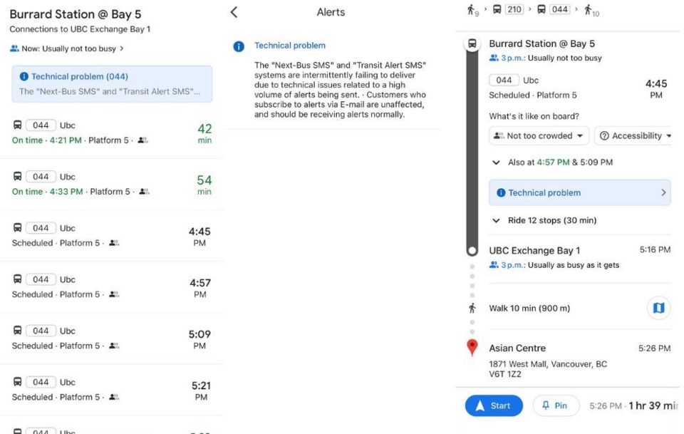
Google Maps
The Google Maps app combines all of the capabilities of the other methods with alerts and information notices, live location updates, and bus schedule options. It also lets travellers know how crowded the bus is expected to be. You have to enter your desired start and end location and can't update as you go without starting the process over which can be a pain but it has the most accurate and abundant information in one place when compared to all the other platforms. It is also TransLink-approved.