
In 1919 two men did what no one else had ever done in B.C. before.
They used the cutting-edge technology of the era to take photos from an angle that humans (at the time) almost never got to see. They took to the skies in a Curtiss JN; it's a type of biplane that was popular after it was developed in 1915, just 12 years after powered, heavier than air flight had been developed.
The pilot was Captain Ernie Hoy, a World War I flying ace who was pioneering air mail at the same time; this historic flight in Vancouver took place in May of 1919 according to the City of Vancouver archives. In August of the same year, he flew the first airmail flight between Vancouver and Calgary, a nearly 17-hour journey through the Rocky Mountains, using a biplane.
Stuart Thomson was the photographer; originally from England, he was trained as a railway worker before arriving in Vancouver where he took up photography as an amateur at first, before turning pro. The city archives has over 8,600 of his photos, from commercial product shots to portraits to news events.
This set of 15 is notable, though, as the first photos of B.C. taken from the air, as Hoy flew around the city.
Historic Vancouver locations depicted in 1919 aerial photographs
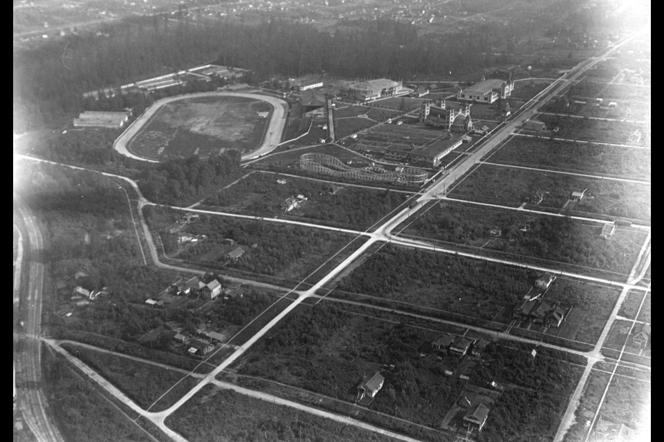
Among the highlights in the series is the shot of Hastings Park with the original roller coaster built there.
There's also the photo taken looking east towards Kits Point, with the area now known as Vanier Park still partially forested and only a handful of houses in the now popular neighbourhood.
The photo looking east along West Georgia is interesting as well, with the second Hotel Vancouver dominating the far skyline. Few structures challenge it for height, though the sun Tower isn't far off.
Another intriguing shot is from above Prospect Point, where the Lions Gate Bridge now comes straight out of the forest. At the time of the photo, it's just a lonely lighthouse and a platform up on top of the cliff. What adds to this shot is the ship steaming into the port below, with smoke billowing up towards the plane.
The photos from North Vancouver show a sparsely populated area, but the photo of the Capilano Valley (pre-damming) looking towards the Lions is pretty spectacular.
You can view larger versions of the above images via these links:
Photo 1 | Photo 2 | Photo 3 | Photo 4 | Photo 5 | Photo 6 | Photo 7 | Photo 8
Photo 9 | Photo 10 | Photo 11 | Photo 12 | Photo 13 | Photo 14 | Photo 15


