
While making it to Banff National Park for a weekend hike might be hard to pull off, British Columbia is home to some of the world's most awe-inspiring vistas.
Even better: most of the best hikes near Vancouver are accessible year-round.
Have a look at some easy hikes or hiking trail systems to enjoy with jaw-dropping views that allow you to see for miles.
Quarry Rock
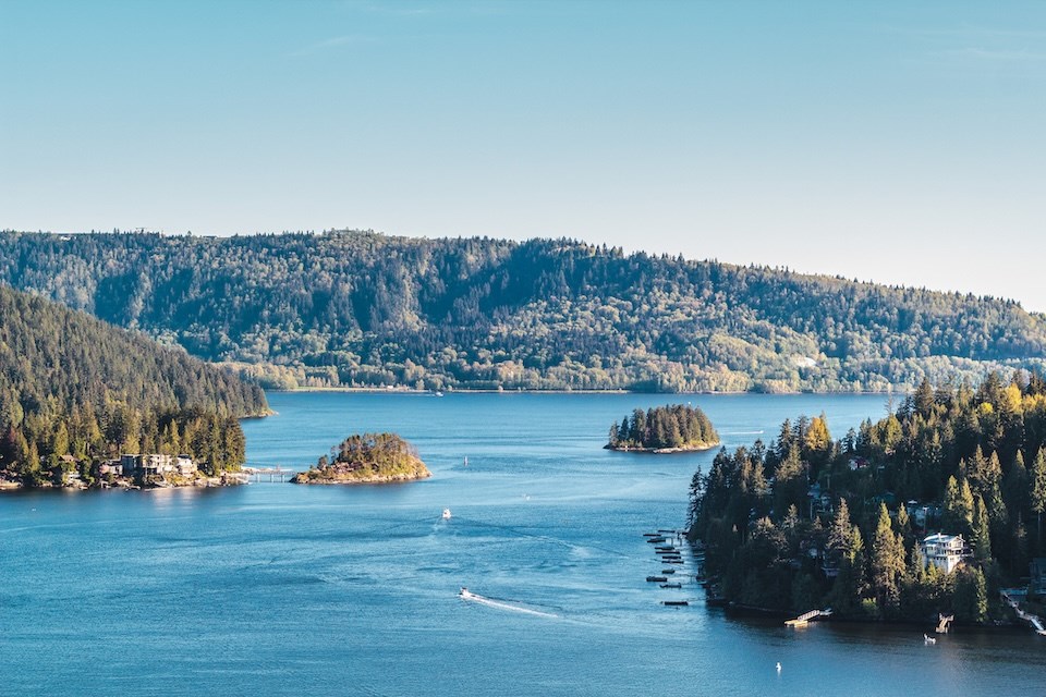
The average length of time needed to reach the peak of this hike is 45 minutes. While it has some incline, it is considered an accessible trail for novice hikers who walk up. Some fit folks even choose to run or bike up the trail.
From the top, locals can enjoy sweeping, 360-degree views of the Indian Arm. The trail is dog-friendly, so Fido doesn't have to stay sad at home.
The trail is considered accessible year-round, but may be closed during or following stormy weather.
The trail is about 3.8 km long and has an elevation of roughly 100 meters, according to Vancouver Trails.
How do you get there?
The Baden Powell Trail is located near the Deep Cove North Shore Marina & Rentals at 2890 Panorama Dr, North Vancouver. Continue walking down Panorama Drive to the easternmost section, which leads to a trail (with signage to guide you).
Public Transportation
- TransLink's 211 Seymour/Phibbs Exchange bus takes roughly an hour from Waterfront SkyTrain Station.
Driving
- Routes take under roughly 35-40 minutes from the downtown area.
Burnaby Mountain Conservation Area
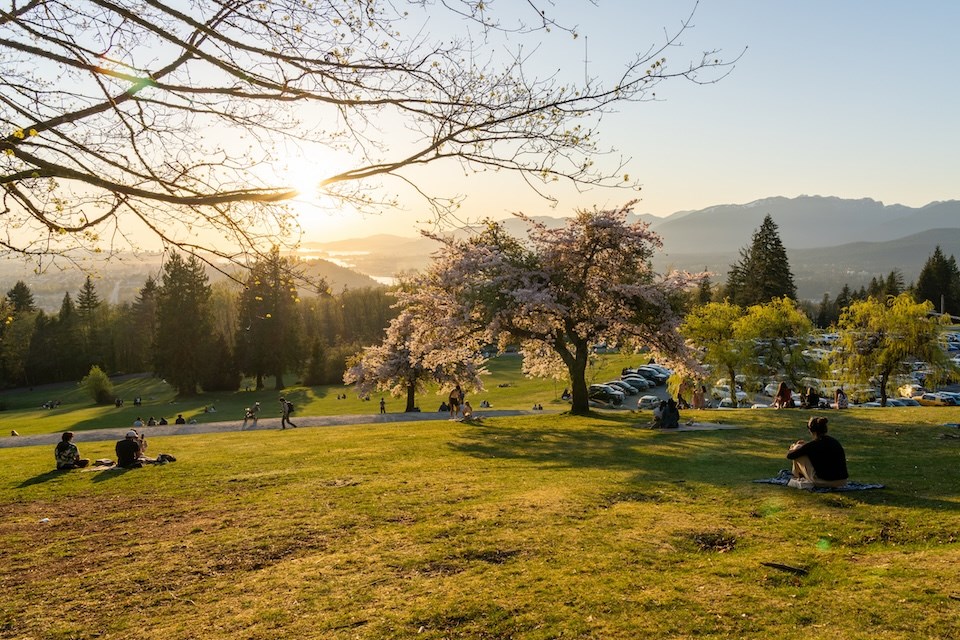
Burnaby Mountain Conservation Area extends over 576 hectares, with the elevation climbing 25 meters above sea level to the summit. The trails wind through the forested mountain slopes of deciduous and coniferous trees. Hikers can spot black tail deer, coyotes, bald eagles and some smaller animals in the park again.
Visitors are warned that black bears and cougars sometimes appear near creeks and streams near the forest trails.
Hikers looking for a "real" workout can visit Burnaby's version of the iconic (Jack Black-approved) Grouse Grind. The Velodrome Trail is a 1,400-metre route that kicks off at Harry Jerome Sports Centre. Alternatively, it is accessible from the gravel parking lot at the Drummond’s Walk trailhead in Barnet Marine Park, on the other side of the Barnet Highway, across from Harry Jerome Sports Centre, according to the City of Burnaby.
How do you get there?
Burnaby Mountain Park is located at 100 Centennial Way. The following directions will take you to the Burnaby Mountain Conservation Area, but you could also start hiking at areas lower down.
Public Transportation
- TransLink's R5 Hastings St/To SFU Exchange bus from Waterfront Station takes about an hour and 15 minutes.
- TransLink riders can also take the Expo Line to Commercial Drive and transfer to the Millennium Line, and then the 145 Production Way bus (it also takes about an hour and 15 minutes).
Driving
- Drivers can take Hastings Street from downtown Vancouver to Burnaby Mountain (it takes about 40 minutes).
Minnekhada Regional Park
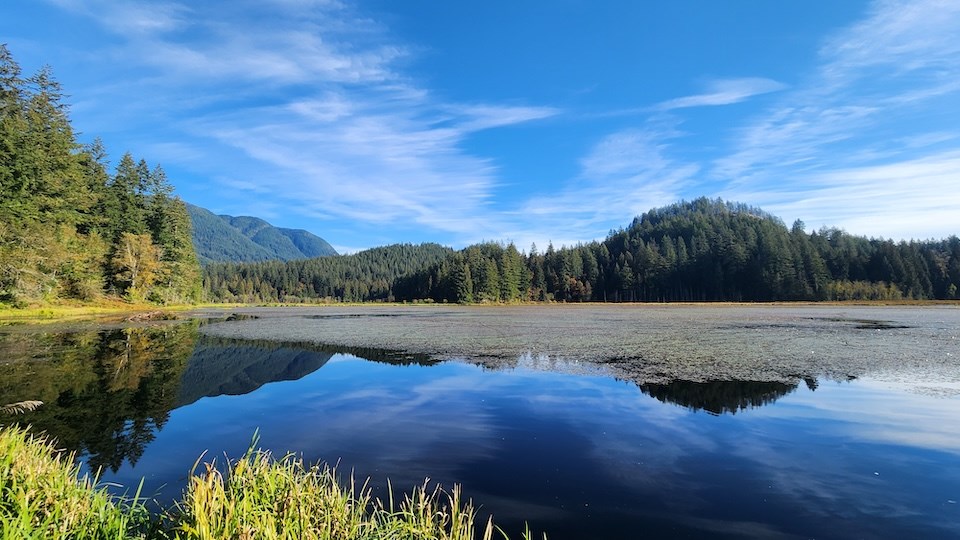
The Minnekhada Regional Park features marshes, rocky outcrops, and lush forested areas, offering an enticing alternative to other hikes near Vancouver.
Dogs are permitted, but must be leashed.
According to Metro Vancouver, a couple of popular, easier trails to enjoy in the park include:
-
Lodge Trail is about 2 km return from the Quarry Road Entrance, and is mostly flat with excellent wildlife viewing along the Lower Marsh. It has a small picnic area, and you can have a peek at Minnekhada Lodge, or continue along Fern Trail.
-
Fern Trail is 2.7 km return from the small picnic area near the lodge. It is described as "rolling with some steep sections," and you can enjoy partial views of Pitt River and Addington Marsh from the Addington Lookout.
The park is open from June 3 to Sept. 1 from 7 a.m. to 9 p.m. and from Sept. 2 to Sept. 22 from 7 a.m. to 8 p.m.
How do you get there?
Minnekhada Regional Park is located at 4000 Quarry Rd in Coquitlam and is accessible from Highway 1.
Public Transportation
- If you aren't driving, public transportation will include a couple of long walks, or a Rideshare or cab option. The 173 Cedar branch departs from TransLink's Coquitlam Station on the Millennium Line, but then it is about a 40-minute walk
Driving
- Routes take just over an hour from the downtown Vancouver area.
Lighthouse Park
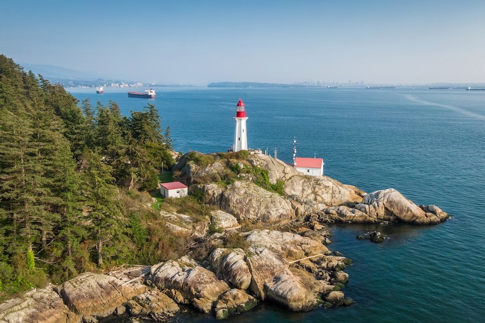
Lighthouse Park on the North Shore yields awe-inspiring views in every direction as you make your way through the forest and down the shore. Folks who only want to score a snap of the main attraction — the stunning, white-and-red Point Atkinson Lighthouse — can follow an easy trail for approximately 10 minutes.
However, the trails can also offer a good workout, with options spanning 6 kilometres that take roughly two hours. Starboat Cove is another ideal spot with stunning views and space to sit down for a picnic. It is located about 15 minutes from Lighthouse Park.
The lighthouse viewpoint offers panoramic ocean views and a cornucopia of sea-faring fowl. Best of all: this unique gem is a short drive from downtown Vancouver.
The trail is dog-friendly, but dogs must be leashed up.
How do you get there?
The entry point to Lighthouse Park is located at 4902 Beacon Ln in West Vancouver, and can be accessed from a parking lot just off Beacon Lane.
Public Transportation
- TransLink's 250 Horseshoe Bay bus takes roughly an hour to get there from Burrard Station (with walking).
Driving
- Routes take under roughly 35-40 minutes from the downtown Vancouver area.
Find more information about exciting destinations in B.C. and across the globe, as well as travel deals and tips, by signing up for V.I.A.'s weekly travel newsletter The Wanderer. Since travel deals can sell out, find out the day they are posted by signing up for our daily Travel Deals newsletter.
Want to learn more about a specific destination or have a travel concern or idea you would like V.I.A. to write about? Email us at [email protected]. Send us stories about recent holidays that you've been on, or if you have any tips you think our readers should know about.


