
Following three decidedly cold, wet winters, Metro Vancouverites may finally have the chance to soak in some warmer weather -- or at least see some temperatures closer to seasonal averages.
Since 2020, the planet has been in the cold phase (La Niña) of the El Niño-Southern Oscillation (ENSO) climate pattern. But this pattern is expected to shift to neutral conditions from February to April.
Rachel H. White, an assistant professor in the Department of Earth, Ocean, and Atmospheric Sciences at the University of British Columbia (UBC), told V.I.A. that the past winter was quite cold, "consistent with the La Niña conditions." That said, not every La Niña year sees below-average temperatures, as the weather is affected by several factors.
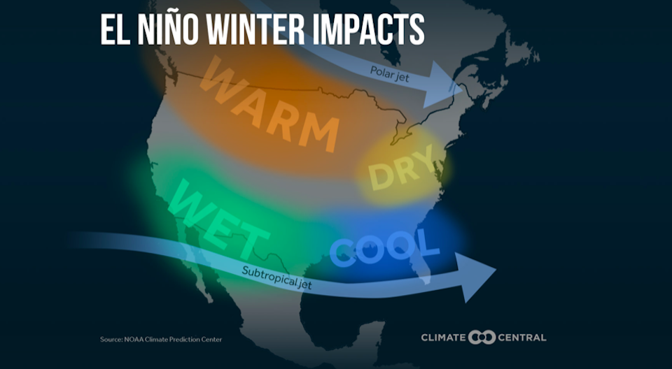
ENSO is part of the natural variability of the climate system. In El Niño years, there are warmer than average sea surface temperatures over the tropical Pacific, which "increases global average temperatures, as the ocean releases heat into the atmosphere," she described.
"In other years (La Niña), the ocean is colder than average in the central/eastern tropical Pacific, and takes up heat from the atmosphere, leading to slightly cooler global average temperatures."
Since the planet is moving out of a La Niña phase into an ENSO neutral, there might be a shift towards slightly warmer conditions. That said, this will already take place locally heading into spring, White explained.
While there is still a significant amount of uncertainty in this forecast, the models from the US National Oceanic and Atmospheric Administration (NOAA) currently suggest that the climate might shift to an El Niño pattern between May and July.
But milder winters and more opportunities to hit the beach aren't the only things that come along with the changing pattern.
Metro Vancouver weather forecast can be affected by global sea surfaces temperatures
There may be near-record (or record, depending on the strength of El Niño) global temperatures as the warming from El Niño combines with the long-term global warming trend, White said.
While El Niño refers to warmer temperatures than average in the central/eastern tropical Pacific, these temperature changes can impact weather a long way away, including in the Pacific Northwest.
"The tropical sea surface temperatures affect the atmospheric circulation patterns that affect our weather, such as the latitude and the strength of the jet stream over the Pacific. I find it pretty incredible that a change in ocean temperatures so far away can have an impact on our weather here. But this also means that the effects of ENSO on Vancouver are probabilistic: an El Niño winter is more likely to be warmer than average over Vancouver, but some aren’t," White noted.
"Many other things can have an influence on our weather for a season, including sea surface temperatures further north in the Pacific Ocean (there is another oscillation called the Pacific Decadal Oscillation), and local sea surface temperatures closer to our coast."
How long the system stays in El Niño, La Niña, or a neutral state is also very variable from each year to the next, she added.


