The Metro Vancouver weather forecast includes calmer conditions following a powerful storm that caused localized flooding and hazardous driving conditions.
On Monday, Dec. 4, an atmospheric river drenched B.C.'s coast with ample rainfall and strong winds. Classified as a Pineapple Express, the weather system originated near Hawaii and brought heavy rainfall to the region for numerous hours.
While amounts varied across the Lower Mainland, heavy rainfall was recorded in every city. Environment Canada's Vancouver International Airport (YVR) weather station recorded 49.8 mm of rain, making Monday Vancouver's wettest day in over two years. Before that, the station recorded 52.5 mm of rainfall on Nov. 14, 2021, when a powerful atmospheric river devastated parts of the Lower Mainland with severe flooding, according to Vancouver Weather Records.
Monday's wet weather event didn't last as long as the one in 2021, which continued for a couple of days. In a previous interview, Environment Canada Meteorologist Armel Castellan told V.I.A. that this event would last for roughly 24 to 30 hours and would be "mostly beneficial," noting that the region sees about "20 to 30 of them annually."
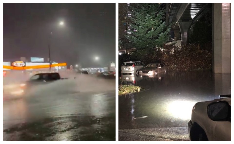
Locals shared videos and photos of the storm's devastation that it wreaked across the Lower Mainland. One of the videos showed logs and debris that were floating down a "very fast-moving" Lynn Creek in North Vancouver.
Full on logs & debris in a very fast moving #LynnCreek in #NorthVancouver #BC on Metro #Vancouver’s #NorthShore as heavy rains & rapid snowmelt cause local streams to swell. A high streamflow advisory and #FloodWatch in effect.
— Ryan Voutilainen 🇨🇦🇫🇮 (@RyanVoutilainen) December 5, 2023
8:50p PT#ShareYourWeather #YVRwx #BCwx #BCstorm… pic.twitter.com/JxRrUcCiWN
Other videos show flooding in other places across the region, including Burnaby, Surrey, Maple Ridge, and Vancouver proper. The National Oceanic and Atmospheric Administration (NOAA) also shared a couple of images that depict the area that received the heaviest amounts of rainfall.
@CBCOnTheCoast Pretty significant flooding in Burnaby close to Gilmore Station. #bcstorm pic.twitter.com/giWIVtpBnt
— Just watch me (@scriber09) December 5, 2023
Parts of 228th and Lougheed Hwy under water in Maple Ridge due to the #AtmosphericRiver with heavy rain continuing overnight. Be careful on the roads out there! @KGordonGlobalBC @GlobalBC @DriveBC #MapleRidge #BCStorm pic.twitter.com/gomtiPPz8s
— Matt Piercy (@mpiercy89) December 5, 2023
Finished the day with 71mm of rain. Eased up for a bit but since increased to a rate of 8.3mm/h. Warm out at 9° #SurreyBC #BCStormWatch #bcstorm #ShareYourWeather pic.twitter.com/0asj85UcEi
— Kyle Marshall (@Kylem87) December 5, 2023
Very nice NOAA composites and a last look at the atmospheric river that brought 100 mm+ rainfall to many parts of the PNW. My location here in Metro Vancouver stands at about 80 mm. #BCstorm https://t.co/xSklp9js7W
— Peter Vogel (@PeterVogel) December 5, 2023
At Gilmore Station/Home Depot, feel bad for the people who’s cars are stuck here #bcstorm #bcstormwatch pic.twitter.com/x8H3x0Ssd0
— Storm Hunter Team (@stormhunterteam) December 5, 2023
Rainy walk #bcstorm #AtmosphericRiver pic.twitter.com/GqrlGvLmvh
— Lindsay McGill (@Lindsay_McGill) December 5, 2023
As of Tuesday morning, avalanche conditions are considered a level three "considerate" or "dangerous" for most of the B.C. coast. Avalanche Canada advises people to exercise caution and allow adequate time for the snowpack to stabilize following heavy overnight rain and/or snow. However, there is an elevated concern in the Hope area, where the avalanche risk remains "high" due to warm, wet, and windy conditions.
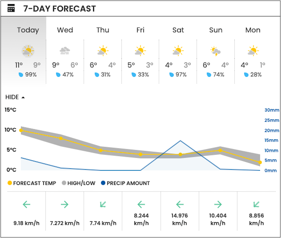
Metro Vancouver weather forecast
While there aren't any major storms in this week's Metro Vancouver weather forecast, it isn't expected to be dry.
For Tuesday, V.I.A.'s Downtown Centre Weatherhood station shows a high of 11 C and an overnight low of 9 C, with a 99 per cent chance of rain. However, rainfall amounts aren't expected to exceed 5 mm. Wednesday's forecast includes similar temperatures but there is a much lower chance that the area will see some precipitation.
Thursday and Friday also look mainly dry but Saturday's forecast includes a 97 per cent chance of wet weather.
While the next couple of weeks are uncertain, Environment Canada expects the Lower Mainland, as well as the rest of B.C., will see a warmer-than-average winter.
Following three chilly La Niña years, El Niño is expected to break the cold run by bringing milder temperatures to the region.