

While Vancouver has seen sunny, dry weather over the past couple of days, this week's forecast looks decidedly wet--and cold.
Environment Canada has issued a special weather statement for the region, with temperatures expected to dip below zero on Saturday and Sunday nights. In addition, snowfall is possible Monday night.
A ridge of high pressure is expected to build Sunday, which will bring modified arctic air over the south coast Monday afternoon. Combined with the modified arctic air, the front will create the potential to produce accumulating snow for neighbourhoods and roadways above 200 metres.
The special weather statement is in effect for:
- Metro Vancouver - central including the City of Vancouver Burnaby and New Westminster
- Metro Vancouver - North Shore including West Vancouver and North Vancouver
- Metro Vancouver - northeast including Coquitlam and Maple Ridge
- Metro Vancouver - southeast including Surrey and Langley
- Metro Vancouver - southwest including Richmond and Delta
The front will move out of the region Tuesday morning, and the forecast calls for a mix of sun and cloud in the afternoon. However, the rain is expected to return Wednesday night and continue through Friday.
Metro Vancouver Weather Forecast
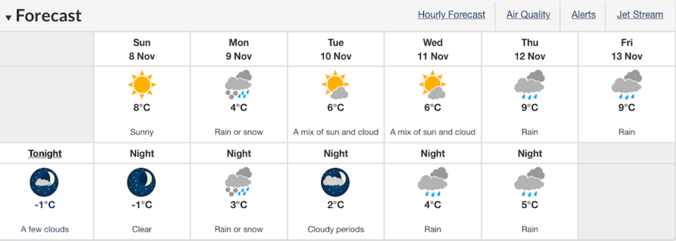 Photo: Environment Canada
With overnight temperatures expected to plunge below freezing across the Lower Mainland this weekend, the City of Vancouver is making extra shelter spaces available for those in need of warmth. View where they are located, here.
Back in October, locals shared videos of early morning snowfall on Burnaby Moutain and just a few minutes north of Vancouver. View the videos, here.
--With a file from Megan Lalonde.


