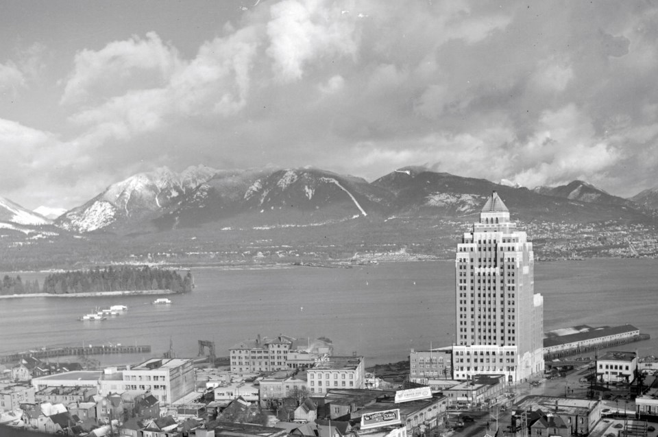
Names like Vancouver, False Creek, and Stanley Park may seem as permanent as the North Shore Mountains now, but they're not really.
They may be on official forms, metal signs, and digital maps, but back in the city's early days (and before that) names weren't as permanent and could evolve or be forgotten altogether. For example, Jericho Beach's name either refers to Jerry's Co. or Jerry's Cove, and over time it got mashed together.
Many of the names were pitched for a project that didn't go very far and therefore the name fell out of use.
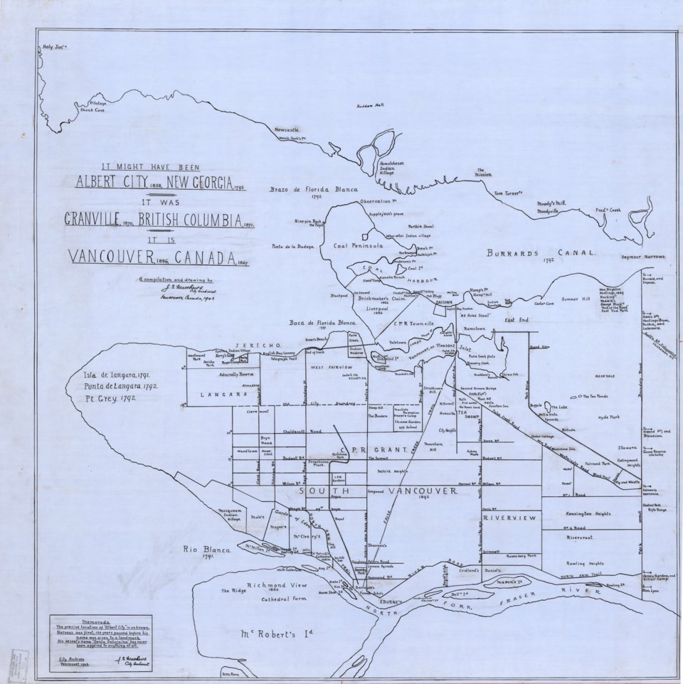
More than 80 years ago the city's first archivist was trying to save some of those names before they disappeared and made a map. Some were for projects that never really took hold while the context for others has been lost.
Map has over 200 place names, forgotten languages
This map was made by archivist Major J.S. Matthews (Major was his military rank he kept using, not an unusual first name); in a 1943 article, Matthews says it took him 10 years to put it together. The map features over 200 place names rarely spoken or that were no longer in use at the time; some have been revived now, to some extent.
Before delving too far into the map and the names, it's important to acknowledge the names used for places around Vancouver by the Musqueam, Squamish, and Tsleil-Waututh and their ancestors.
Some of those names are still in use or being revived. Both the Musqueam and the Squamish have maps that show the names of places used for hundreds, if not thousands, of years by the people living locally. The Tsleil-Waututh have a map that shows the streams and shoreline as it was before contact. There's another, more comprehensive map with names used by many of the province's Indigenous people.
Some of those places were X̱wáýx̱way (in what's now Stanley Park), c̓əsnaʔəm (in what is now Marpole), and Sen̓áḵw (in Kitsilano) near the entrance to False Creek.
The Matthews map has some references to Indigenous places (with thoroughly anglicized spellings) along with many, many names given by settlers to the places as people of European descent (mainly English-speaking).
Highlights from the map
With more than 200 names on the map, there are plenty to sift through.
Some are pretty big. Like the fact that Vancouver could have been called Albert City. Before Canada existed, the English government based back east decided there needed to be a transcontinental wagon road. While there were plenty of cities in the east for it to pass through, its western terminus was less obvious; Fort Langley wasn't quite on the coast and Fort Victoria wasn't quite on the mainland.
So they picked a spot and said "Albert City" should go there. Coincidentally, they picked where Vancouver sits now because of English Bay. In the end, a railway was built instead and ended up in the same spot.
And Albert City was nearly a city in New Georgia; that's what Capt. George Vancouver called the area when he first explored it; north of New Georgia were New Hanover and New Bremen. It's unclear how the Sunshine Coast resembles northern German cities.
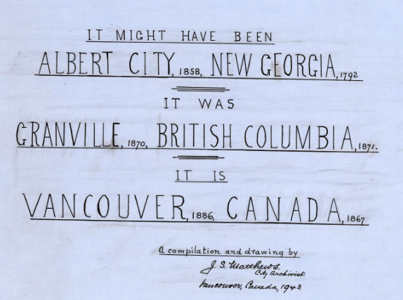 Vancouver itself was called Granville for a period before the captain's name came into use. And, of course, Gastown used to refer to the whole (albeit tiny) community in its earliest days before becoming a neighbourhood name within the city.
If the Spanish, who explored the area before the English, had gotten to keep their labels on things, some of the natural landforms would have different names these days.
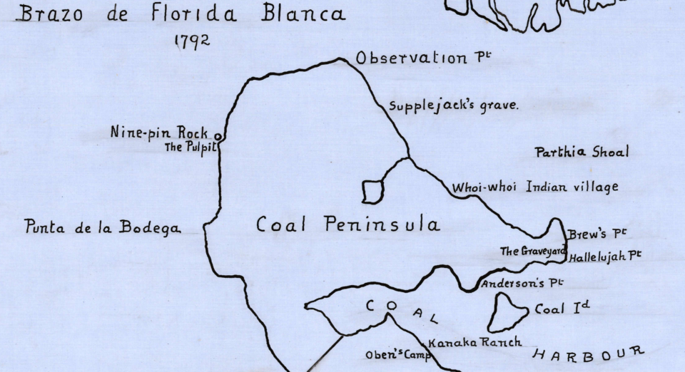
The entrance (or Lions Gate, if you will) to the Burrard Inlet (or Burrard Canal, as it was first called) would have been the Braza de Florida Blanca, while the entrance to False Creek would have been part of the Boca de Florida Blanca. Spanish explorers thought there was a much larger body of water here, and that Point Grey was an island, they called it Isla de Langara at first, and Punta de Langara later.
Perhaps coincidentally, Florida Blanca is a reference to white flowers, while B.C.'s provincial flower is the dogwood, which is a white bloom.
The Fraser River, meanwhile was labelled the Rio Blanca (White River).
Undoubtedly the Spanish had other names for spots around the area, but Matthews only notes one other: Punta de la Bodega (now Ferguson Point) in what's now Stanley Park (which is on the headland formerly known as Coal Peninsula).
Speaking of the use of "Coal" in names, it popped up a lot, including Coal Island, which is now known as Deadman's Island.
Lots in Stanely Park has changed (like the aforementioned X̱wáýx̱way). Slhx̱i7lsh was also known as Nine Pin Rock or the Pulpit; its more recent name, Siwash Rock, is derived from a word that means savage.
There was also Observation Point (now Prospect Point), Supple Jack's grave (the former site of August Jack Khahtsahlano's father's grave near Lumberman's Arch), and the Graveyard (aka the Pioneers Cemetery) on Brockton Point.
 The English had a habit of reusing English place names; developers tried dubbing the West End Liverpool in the 1880s and English Bay Beach was Blackpool. These were both part of the massive West End Lot 185, which was dubbed the Brickmaker's Claim in 1862 after the three men who bought it.
There was also a townsite planned in what's now West Vancouver called Newcastle.
Lots of other neighbourhoods had different names for a while, like Langara (Point Grey), West Fairview (Kitsilano), and Eburne (Marpole). Some of the more fun ones are Ramstown (an area around Strathcona), the Garden of Eden (part of the Southlands), and a literal Hicksville at the southern end of Mount Pleasant (named after a family of Hicks who lived there).
Several physical features on the map don't exist anymore, including plenty of creeks like Brewery Creek or China Creek, the Two Ponds (in East Vancouver, east of Trout Lake), and the Bluff (which was somewhere around Canada Place).
There were also more islands in the Fraser River (Amy, Eva, and Mason's, for example). Some of the islands are gone, and others have been incorporated into other pieces of land (Mason's is part of Mitchell Island).
And Little Mountain wasn't always called that, it had a name that is somehow less creative: Mountain Hill.
There were lots of more fun place names, though. In Marpole there was a spot on the river called French John's, in Joyce-Collingwood there was a location called the Pig and Whistle, and somewhere on False Creek near the Plaza of Nations was known simply as Slaughterhouse.
Speaking of False Creek, it was also nearly Vancouver or Pleasant Inlet, which is perhaps more accurate than False Creek.
Matthews also noted the "85 Acre Steal" which was a reference to the CPR's deal which saw them get a lot of land in Vancouver (a UBC document notes it was about 40 acres, but the nickname stuck).
Some other interesting names include Kanaka Ranch in Coal Harbour (a reference to the Hawaiian people who moved to B.C.), Britcola (it was used at a post office and BC Electric Rail station in South Vancouver), and a literal No Man's Land just north of Tea Swamp (which is now a park).
Outside of Vancouver, a few place names are noted as well, like McRobert's Island (now known as Lulu Island), Edmonia (somewhere east of Vancouver in the Burnaby area), and Skunk Cove out in West Vancouver (renamed as Caulfeild Cove).
Major J.S. Matthews' 1943 map of forgotten Vancouver place names: