
After the city saw its earliest snowfall in a whopping three decades Monday (Nov. 7) night, the forecast includes another opportunity for the white stuff this week.
Temperatures fell below freezing across Metro Vancouver Tuesday night, with more frigid temperatures expected over the next couple of nights.
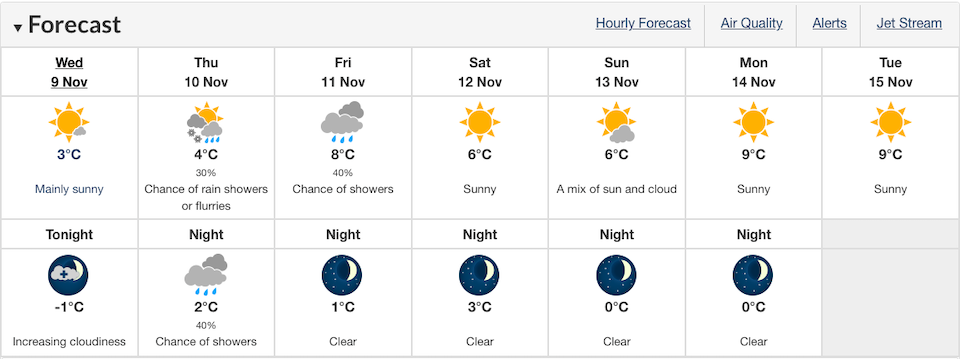
On Wednesday night, for example, temperatures are expected to dip below freezing to -1 C, with increasing cloudiness overnight. With winds up to 15 km/h in the morning, however, the early morning temperatures will feel more like -6 C with wind chill.
Thursday's forecast also includes the week's only opportunity for snowfall this week. There is a 30 per cent chance of rain showers or flurries during the morning followed by a mix of sun and clouds in the afternoon with a high of 4 C.
Thursday night is expected to be less cold, with an overnight low of 2 C with a 40 per cent chance of showers.
Friday may also see some wet weather, with a 40 per cent chance of showers expected during the day. Skies are expected to clear overnight, however, and temperatures dropping to a low of 1 C.
Starting on Saturday the forecast calls for multiple dry days with sunshine and clear skies.
Metro Vancouver weather forecast
Following a powerful windstorm that felled upwards of 400 trees on Friday night, snow blanketed places at higher elevations on Sunday. Following that, places at sea level in Vancouver received their first snowfall on Monday night, which was the city's earliest snowfall in over three decades.
After next week, Environment Canada calls for temperatures across the region to rise closer to seasonal averages, Charbonneau noted.
In a recent update, the National Oceanic and Atmospheric Administration (NOAA) called for a 75 per cent chance that La Niña will be present this winter and won't change to a "neutral" weather pattern until about February.
Typically, La Niña's impact on southern B.C. doesn't start to show until the late fall or early winter. But it does tend to produce cooler than normal conditions and snowier conditions over the mountains.
Environment Canada will release its official winter forecast on Dec. 1.


