
B.C. residents are advised to brace for what has been described as the third "weather bomb" set to strike the coast in three weeks.
The Weather Network says a third "bomb cyclone" in under three weeks will hit the province as an unsettled storm pattern continues to wreak havoc on the west coast.
This system will rapidly intensify and reach "weather bomb" status — a system that's pressure drops at least 24 millibars in 24 hours.
While rain and high elevation snow eased Monday (Nov. 8), the next system is expected to bring "powerful southeast winds over the west coast of Vancouver Island, the Central Coast and Haida Gwaii" that may down trees and cause power outages.
"We have our third ‘weather bomb’ (bombogenesis) in less than three weeks about to rapidly intensify. Its proximity to northern Vancouver Island means this will be quite the windstorm for some,” says Tyler Hamilton, a meteorologist at The Weather Network.
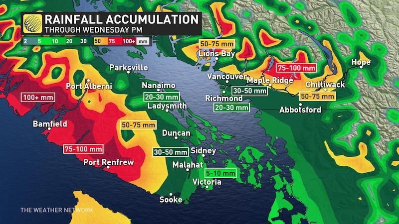
In Metro Vancouver, the stormy system is forecast to bring accumulative rainfall totals up to 60 mm Tuesday, as well as strong southeast winds.
Seven-day rainfall totals continue to be 70-150 mm for the Lower Mainland, including Metro Vancouver, and 150-300 mm for the higher terrain and west coast of Vancouver Island.
The low-pressure system north of Vancouver Island is expected to die out by Wednesday, "but high pressure south of the border will redirect some residual moisture into the South Coast as it runs into that cold air."
There's a risk for downed trees and power outages with these powerful winds.


