
There's no shortage of beautiful outdoor spaces to explore around Vancouver. Luckily for those of us who get to call B.C. home, many of those spots involve waterfalls. (According to the World Waterfall Database, 2,465 across the province, to be exact.)
Not only are B.C.'s waterfalls inherently Instagrammable, but they also make for a foolproof plan when Mother Nature gets a little moody. The cool mist can provide some sweet relief from the heat on a scorching summer day, while the view of a waterfall can't really be foiled by heavy rain clouds like you might experience atop some nearby summits.
Better yet, there are equally impressive falls to match every mood, whether you're looking to stay close to the city or get out of town, or whether you're willing to walk only a few steps from your vehicle or down to hike hours into a remote forest.
There's also never been a more attractive time to go chasing waterfalls than during the COVID-19 pandemic. As B.C.'s public health officials continue to encourage locals and visitors to spend time outside in search of fewer faces and bigger spaces, here are eight spots to consider adding to your must-visit list.
1. Cypress Falls
Head to the North Shore's Cypress Falls Park, where you can stroll through a dense forest of 300-year-old Cedar and Douglas Fir trees past not one, but two beautiful waterfalls.
While the first falls are just a short walk from the parking lot, the upper falls will take hikers about half an hour to reach. There you'll find a rocky viewing area where you can stop and take in the sight and sound of rushing water as it flows over the edge and drops into the canyon below.
Feel free to bring along your four-legged family members too - Cypress Falls Park is a designated off-leash area where well-behaved dogs are free to roam. However, owners are cautioned to be mindful of bears in the area.
THE DETAILS
Difficulty: Easy
Time: Approximately 1.5 hours
Round-Trip: 3km
Elevation Gain: 130 meters
Drive from Vancouver: 30 minutes
Directions: Take Upper Levels Highway exit 4 to Woodgreen/Caulfeild Drive. Turn right at the stop sign onto Woodgreen Drive. Turn right onto Woodgreen Place, which leads to the parking lot and trailhead.
More details: Cypress Falls Park
2. Norvan Falls
This hike takes waterfall hunters through the lush forests of Lynn Headwaters Regional Park in North Vancouver. As you continue along the trail, you can see remnants of the logging operations that took place in the area early 1900's, eventually reaching Norvan Creek and the rugged steel suspension bridge on your left. Make sure to turn right, following the creek uphill, where you'll catch your first glimpse of the thundering falls.
This waterfall might require a bit of a longer trek than other destinations on this list, but the view is worth every step.
THE DETAILS
Difficulty: Intermediate
Time: 5 hours
Round-Trip: 14 km
Elevation Gain: 195 meters
Drive from Vancouver: 40 minutes
Directions: Take Highway 1 to the Lynn Canyon Exit and follow Lynn Valley Road northbound, past the turnoff to Lynn Canyon Park. Where the road turns left, continue going straight along the narrow road to the last parking lot. If you're travelling by public transit, start by taking the Seabus from downtown Vancouver across to North Vancouver. From the Lonsdale Quay bus loop, take bus #228 to Lynn Valley. You will want to get off of the bus near the end of the route at Dempsey and Lynn Valley Road. Walk down the paved road into the forest towards the parking area to reach the start of the trail.
More details: Norvan Falls Hike
3. Kennedy Falls
Not far from the previous waterfall on this list is Kennedy Falls, similarly located in North Vancouver. The rugged, muddy trail takes adventurous hikers into the North Shore's backcountry, along the east side of Mount Fromme and to the west of Lynn Creek. In addition to the stunning falls, you'll also pass an enormous old-growth cedar tree on your way.
THE DETAILS
Difficulty: Intermediate
Time: 5 hours
Round-Trip: 10 km
Elevation Gain: 150 meters
Drive from Vancouver: 30 minutes
Directions: From the Second Narrows Bridge, take Exit #21 and follow Mountain Highway north towards Mount Fromme. If you're crossing the Lion’s Gate Bridge, meanwhile, take Marine Drive east towards Capilano Road. Take Capilano Road north to the Highway 1 east, exit onto Lynn Valley Road, and turn north onto Mountain Highway. Follow that road up towards Mount Fromme.
More details: Kennedy Falls Trail
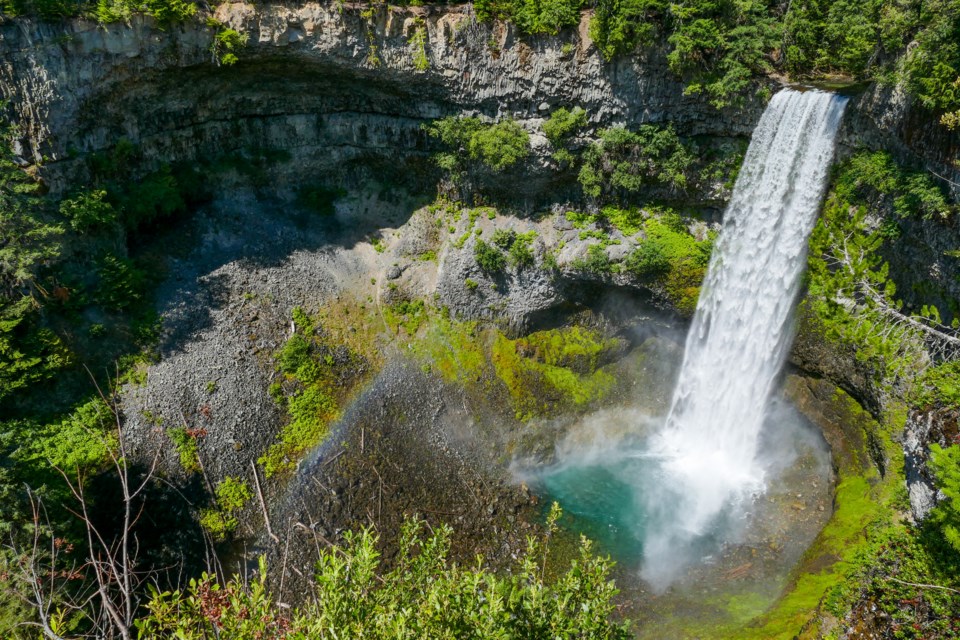
4. Brandywine Falls
This spectacular 70-metre waterfall makes for a great pit stop on a road trip up to Whistler. It's best observed from the Brandywine Falls Provincial Park's viewpoint, just across the train tracks, from which you can also marvel at views of Daisy Lake and the surrounding coast mountains. If you visit on a sunny day, make sure to snap a photo of a rainbow in the falls' mist.
The park is an ideal spot for a picnic, and also connects hikers and mountain bikers with the renowned Sea to Sky trail.
THE DETAILS
Difficulty: Easy
Time: 30 minutes
Round-Trip: 1 km
Elevation Gain: minimal
Drive from Vancouver: 1 hour, 40 minutes
Directions: Brandywine Falls is located on the east side of Sea To Sky Highway, about 11 km south of Whistler. If travelling from Vancouver, turn right into the parking lot from Highway 99.
More details: Brandywine Falls Provincial Park
5. Crooked Falls
Located just north of Squamish in the Upper Squamish Valley, the trail leading to these hidden falls offers unique views looking directly at the roaring waterfall from its side, as well as a stunning view of the Squamish Valley below. The hike to this waterfall does feature several steep, rocky sections.
THE DETAILS
Difficulty: Intermediate
Time: 3 hours
Round-Trip: 6 km
Elevation Gain: 380 meters
Drive from Vancouver: 1 hour, 30 minutes
Directions: From Vancouver, head north on Highway 99 through Squamish, before turning left onto the Squamish Valley Road. Follow the Squamish Valley Road, turning left and continuing after crossing a bridge until the paved road ends and turns to gravel. Drive another 1.5km until you reach the Ashlu Bridge and turn left across the one-way bridge. Follow Ashlu Road and watch for kilometer signs. Just after the kilometre-2 sign, the road veers to the right. The trailhead can be found next to an electrical pole on the left side.
More details: Crooked Falls
6. Nairn Falls
Located at the north end of the Sea to Sky corridor just south of the village of Pemberton, you can find the glacier-fed waters of Nairn Falls carving their way through a rugged canyon. At the end of a mostly flat walking trail that follows a fast-flowing river, you'll find a rocky viewing area with perfect views of the falls.
THE DETAILS
Difficulty: Easy
Time: Approximately 1.5 hours
Round-Trip: 3km
Elevation Gain: minimal
Drive from Vancouver: 2 hours, 20 minutes
Directions: Drive north on Highway 99, passing through both Squamish and Whistler. Before pulling into Pemberton, keep an eye out for the Nairn Falls parking lot on the east side of the highway.
More details: Nairn Falls Provincial Park
7. Shannon Falls
Undoubtedly one of the most impressive sights in the area, Squamish's Shannon Falls holds the title of B.C.'s third-highest waterfall at a whopping 335 metres.
Although the tumbling falls are visible from the Sea to Sky Highway, drop by Shannon Falls Provincial Park for a closer look, just steps from the parking lot. Those looking for more of a challenge can also hike to the top via the Upper Shannon Falls Trail for a stunning view of the Howe Sound below, but be sure to stay far away from the sharp cliffs and flowing water, even if some of the pools atop the falls look invitingly - and deceptively - calm.
THE DETAILS
Difficulty: Easy
Time: 30 minutes
Round-Trip: 1 km
Elevation Gain: minimal
Drive from Vancouver: 1 hour
Directions: Drive north on Highway 99 toward Squamish and Whistler. Shannon Falls is located on the east side of the highway, just south of Stawamus Chief Provincial Park.
More details: Shannon Falls Provincial Park
8. Crystal Falls (Coquitlam)
Located just east of Vancouver, Coquitlam's Crystal Falls tumble into the Coquitlam River and is located along a short, family-friendly hiking trail - perfect when you want to get some exercise outside, but aren't looking for too big of a challenge.
While this low elevation hike can be completed year-round, a summertime day trip gives you the chance to bring along your bathing suit for a dip in the river or the canyon pools just above the falls.
THE DETAILS
Difficulty: Easy
Time: 2 hours
Round-Trip: 7 km
Elevation Gain: minimal
Drive from Vancouver: 45 minutes
Directions: The trail to Crystal Falls is located on the Coquitlam River along a residential area on Karley Crescent.
More details: Crystal Falls
As always, be sure to check current weather, terrain, and wildlife conditions prior to embarking on a hike. In addition, make sure that you know your physical limitations, tell someone where you are going beforehand, bring enough food and water, wear appropriate clothing, and never hike alone. Don’t attempt dangerous poses for photographs.
For more tips about how to make your visit to any one of these stunning waterfalls a safe one, read this.
Visit Vancouver Trails online for a detailed list of safety tips and things to consider before your next hike.
An earlier version of this story included incorrect directions to Norvan Falls. This story has been updated to include the correct information - make sure to turn right before the trail's suspension bridge, do not cross it. V.I.A. apologizes for the error.


