
Tourism has long been a part of Vancouver, even if it wasn't always the biggest industry here.
And before Google Maps, GPS and Siri, there were paper maps to guide newcomers around. This is probably not news to you.
In the City of Vancouver Archives there are dozens, if not hundreds of different maps, but here are six examples that were specifically created for Vancouver's visitors.
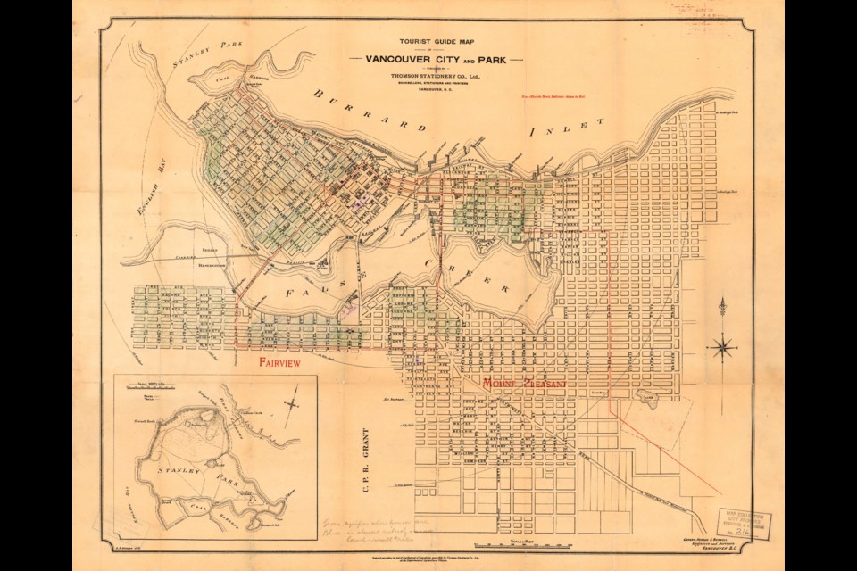
The oldest dates from 1898 and is actually the most precise of the maps in that it doesn't warp any distances. It's actually pretty much a street map, but with "Tourist Guide Map" across the top. At this time Vancouver wasn't much of a tourist town, and the tourism industry globally was nothing like it is now. Most of the attractions Vancouver had at the time were things locals enjoyed on a regular basis, like Stanley Park.
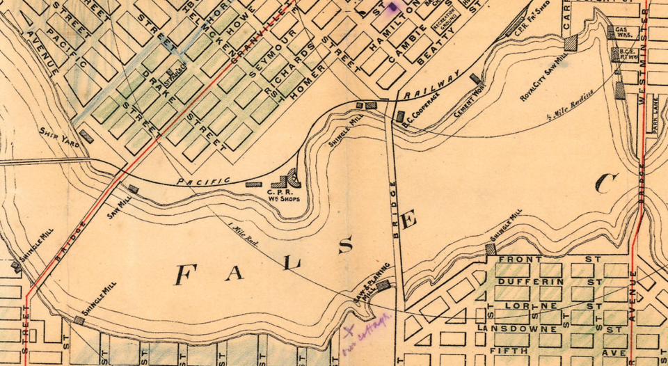
The lack of tourism sites is maybe most noticeable when you see how many industrial sites are marked. False Creek alone has multiple shingle mills and sawmills along with a shipyard, cooperage and the CPR's workshops.
While not part of the official map, someone has also coloured in some sections of the map; green for buildings and blue for small trees and vacant lots. That means most of the West End was empty of structures at this time.
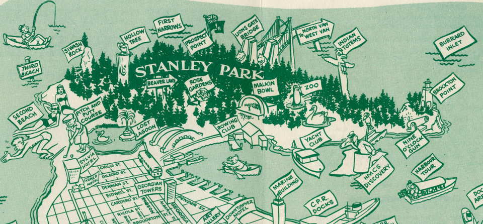
The next oldest, from 1923, is focused on Stanley Park and features a bit more an artistic eye. It also points out things like viewpoints, local nicknames and services.
Many of the items marked are still in the park, like the rose gardens, Brockton Oval and Time Gun (the original and much more awesome name for the 9 o'clock gun).
There are several things that are gone, and a couple of notable things missing. The biggest thing not on the map is the Lions Gate Bridge, which was still a decade off. No longer in existence is the beaver colony near the rowing club, the Second Beach tea room (though there's still food on offer at the beach), and the semaphore station.
And there's one thing that wasn't there when the map was made, and also isn't there now. A spotted is noted to be the site of a proposed First Nation village. It didn't come to be, but the site appears to be near where X̱wáýx̱way stood for thousands of years before the park was created.
The next oldest is from 1936 and it's one of the more problematic maps, with stereotypical depictions of local First Nations. At the same time, it appears to attempt to embrace local First Nations culture with depictions of local art along the edges.
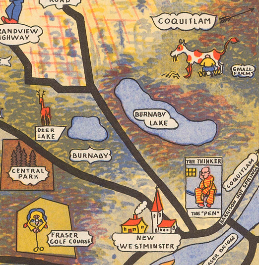
Speaking of art, this map is almost as much an artistic representation of the city as it is useful guide. Tourist sites are pointed out, only major roads are given and little graphics populate the city, with gardeners, drivers and golfers in all sorts of situations.
And for some reason, a giant house near what is now the Boundary Bay airport is labelled 'American Hairless Hot Dogs.'
This map actually comes from an old gift shop in Vancouver, which, according to the map, neighboured the Orpheum Theatre.
Two maps from the 50s really amp up the creativity. One from 1954 is actually quite similar to the previous map, with art around the outside. While it's more detailed, it also notes many sites around town that may interest people, including parks and schools. Churches, hospitals and military sites also make the grade.
The next has a lighter tone. From 1955 it shows the city's core and Stanley Park, with North Vancouver and the mountains in the background taking on a big role. It appears the artist really enjoyed drawing skiers.
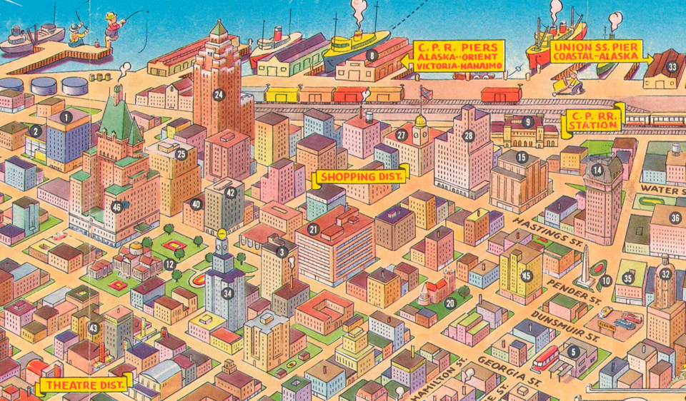
This one really shows the buildings in the city's downtown, which are very different from today's urban centre. Hotel Vancouver and the Marine Building tower over everything nearby, an industrial district sits where some of the priciest residential towers in Vancouver stand today and iconic buildings (associated with Expo 86) don't exist (BC Place, Canada Place and Science World). The landscape looks like Vancouver, but a lot of the recognizable details are missing.
The most recent map is a Gray Line bus map, which was used to advertise tours around the city. It's also likely the least accurate as it compresses Stanley Park into a somewhat curved peninsula, and is pretty loose with which details make the grade. Hotels and motels show up a lot, while many things that might be considered an attraction are left off or minimized.
Perhaps the most shocking thing, though, are the prices. A Triple Package Tour offers 90 miles of sightseeing for $8.50, while the Evening with Gray Line lasts more than 6 hours, includes dinner and good companionship for just $11.15.


